Hershey, Nebraska
Hershey, Nebraska | |
|---|---|
 Downtown Hershey | |
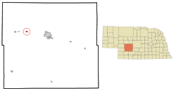
 Location of Hershey, Nebraska | |
| Coordinates: 41°9′29″N 101°0′6″W / 41.15806°N 101.00167°W | |
| Country | United States |
| State | Nebraska |
| County | Lincoln |
| Area | |
| • Total | 0.76 sq mi (1.98 km2) |
| • Land | 0.76 sq mi (1.98 km2) |
| • Water | 0.00 sq mi (0.00 km2) |
| Elevation | 2,900 ft (884 m) |
| Population | |
| • Total | 649 |
| • Density | 850.59/sq mi (328.30/km2) |
| Time zone | UTC-6 (Central (CST)) |
| • Summer (DST) | UTC-5 (CDT) |
| ZIP code | 69143 |
| Area code | 308 |
| FIPS code | 31-22290[3] |
| GNIS feature ID | 0829938[4] |
Hershey is a village in Lincoln County, Nebraska, United States. It is part of the North Platte, Nebraska Micropolitan Statistical Area. The population was 649 at the 2020 census.[2]
References[change | change source]
- ↑ "ArcGIS REST Services Directory". United States Census Bureau. Retrieved September 18, 2022.
- ↑ 2.0 2.1 "Hershey village, Nebraska". United States Census Bureau. Retrieved July 28, 2023.
- ↑ "U.S. Census website". United States Census Bureau. Retrieved 2008-01-31.
- ↑ "US Board on Geographic Names". United States Geological Survey. 2007-10-25. Retrieved 2008-01-31.
