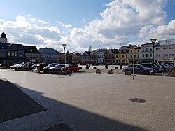
Hlučín
Hlučín | |
|---|---|
 Mírové Square | |
| Coordinates: 49°53′48″N 18°11′35″E / 49.89667°N 18.19306°E | |
| Country | |
| Region | Moravian-Silesian |
| District | Opava |
| First mentioned | 1303 |
| Government | |
| • Mayor | Petra Tesková |
| Area | |
| • Total | 21.14 km2 (8.16 sq mi) |
| Elevation | 241 m (791 ft) |
| Population (2023-01-01)[1] | |
| • Total | 13,506 |
| • Density | 640/km2 (1,700/sq mi) |
| Time zone | UTC+1 (CET) |
| • Summer (DST) | UTC+2 (CEST) |
| Postal code | 748 01 |
| Website | www |
Hlučín (German: Hultschin; Polish: Hulczyn) is a town in Opava District in the Moravian-Silesian Region of the Czech Republic. About 14,000 people live there. It was the center of the Hlučín Region.
Twin towns[change | change source]
Hlučín is twinned with:
 Namysłów, Poland
 Nebelschütz, Germany
 Ružomberok, Slovakia
References[change | change source]
Other websites[change | change source]
Wikimedia Commons has media related to Hlučín.
- Official website (in Czech)


