Holden, Massachusetts
Holden, Massachusetts | |
|---|---|
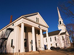
 Holden Center | |
 Location in Worcester County and the state of Massachusetts. | |
| Coordinates: 42°21′06″N 71°51′50″W / 42.35167°N 71.86389°W | |
| Country | United States |
| State | Massachusetts |
| County | Worcester |
| Settled | 1723 |
| Incorporated | 1741 |
| Government | |
| • Type | Open town meeting |
| Area | |
| • Total | 36.3 sq mi (94.1 km2) |
| • Land | 35.1 sq mi (90.9 km2) |
| • Water | 1.2 sq mi (3.2 km2) |
| Elevation | 860 ft (262 m) |
| Population (2020)[2] | |
| • Total | 19,905 |
| • Density | 550/sq mi (210/km2) |
| Time zone | UTC-5 (Eastern) |
| • Summer (DST) | UTC-4 (Eastern) |
| ZIP code | 01520 & 01522 |
| Area code | 508 / 774 |
| FIPS code | 25-30560 |
| GNIS feature ID | 0618365 |
| Website | www |
Holden is a town in Worcester County, Massachusetts, United States. The town was founded in 1741.
The population was 19,905 at the 2020 census.[2]
Holden was named for Samuel Holden, a director of the Bank of England.[3]
References[change | change source]
- ↑ "2020 U.S. Gazetteer Files". United States Census Bureau. Retrieved March 4, 2024.
- ↑ 2.0 2.1 "QuickFacts: Holden town, Worcester County, Massachusetts". United States Census Bureau. Retrieved March 4, 2024.
- ↑ Gannett, Henry (1905). The Origin of Certain Place Names in the United States. Govt. Print. Off. pp. 158.


