Houtman Abrolhos
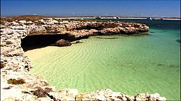
 A bay in the Houtman Abrolhos | |
| Geography | |
|---|---|
| Location | Indian Ocean |
| Coordinates | 28°43′S 113°47′E / 28.717°S 113.783°E |
| Archipelago | Houtman Abrolhos |
| Total islands | 122 |
| Area | 16.4 km2 (6.3 sq mi) |
| Administration | |
Australia | |
| State | Western Australia |
| Federal electorates | Durack[1] |
| State electorate | Geraldton[2] |
| LGA | City of Greater Geraldton[3] |
| Demographics | |
| Population | 6[4] (2016 census) |
| Ethnic groups | Australians |
| Additional information | |
| Southernmost true coral reef in the Indian Ocean | |
The Houtman Abrolhos (English: /hutmən əbrœɭəs/; Portuguese: [ɐˌbɾoˈʎo]), commonly called the Abrolhos Islands, are a chain of 122 islands and reefs in the Indian Ocean, off the coast of Geraldton, Western Australia. It is the southernmost true coral reef in Australia. It is made up of three groups: the Easter Group, the Pelsaert Griup and the Wallabi Group.
The islands are well known for being the site of many shipwrecks, most notably the shipwrecks of the Batavia and the Zeewijk.
The islands are inhabited for part of the year by fishermen and their families. The islands can also be visited by tourists.
Government[change | change source]
The islands are a part of Western Australia. In federal politics, they are part of the Division of Durack.[1]In state politics, they are part of the electoral district of Geraldton.[2] In local politics, they are part of the City of Greater Geraldton LGA.[5]
The islands have been considered a national park by the Western Australian Government since 2019. They are managed by the Department of Fisheries.
References[change | change source]
- ↑ 1.0 1.1 https://www.aec.gov.au/profiles/wa/files/2021/2021-AEC-WA-A3-Durack-Final.pdf
- ↑ 2.0 2.1 "Current Boundaries". www.boundaries.wa.gov.au. Western Australian Electoral Commission. Retrieved 17 February 2023.
- ↑ "Abrolhos Islands Tourism" (PDF). City of Greater Geraldton. Archived from the original (PDF) on 27 March 2021. Retrieved 1 August 2020.
- ↑ "2016 Census QuickStats: Houtman Abrolhos". quickstats.censusdata.abs.gov.au. Archived from the original on 2019-06-16. Retrieved 2023-07-12.
- ↑ "SLIP Map". maps.slip.wa.gov.au. Landgate. Retrieved 17 February 2023.


