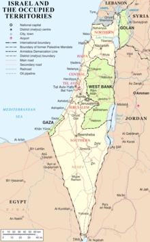
Israeli-occupied territories

The Israeli Occupied Territories are areas of which their current borders originate from the Six-Day-War in 1967, when Israel took control over the West Bank, the Gaza Strip[1] and the Golan Heights.[2]
West Bank[change | change source]
Golan Heights[change | change source]
References[change | change source]
- ↑ Efrat, Elisha (2006). The West Bank and Gaza Strip: a geography of occupation and disengagement. London: Routledge. ISBN 978-0-415-38544-2.
- ↑ Davis, U. (1983-01-01). "The Golan Heights under Israeli occupation 1967-1981".
{{cite journal}}: Cite journal requires|journal=(help)
