Kalasha Valleys
Kalash Valleys
وادی کیلاش Kaĺaśa Desh | |
|---|---|
 These remote valleys are home to the animist Kalash people. following the Kalasha religion. | |
| Coordinates: 35°42′2″N 71°41′29″E / 35.70056°N 71.69139°E | |
| Country | Pakistan |
| Province | Khyber Pakhtunkhwa |
| District | Chitral District |
| Area | |
| • Total | 456.58 km2 (176.29 sq mi) |
| Elevation | 1,670 m (5,480 ft) |
| Population (2003) | |
| • Total | 9,000 |
| • Density | 20/km2 (51/sq mi) |
| Time zone | UTC+5 (PST) |
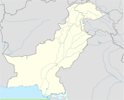
The Kalasha Valleys or Kalasha Desh (Kalasha-mondr: کالؕاݰا دیݰ Kaĺaśa Desh; Urdu: وادی کیلاش) are a number of valleys in southern regions of Chitral in northwestern Pakistan.[1] The people living there are known as the Kalash people. They have their own customs, and religions. The valleys are surrounded by the Hindu Kush mountain range and are close to the border with Afghanistan. Before they were converted to Islam, the Nuristani people living next to the Kalash people had very similar beliefs.
There are three main valleys.[2] The largest one, where most people live is called Bumburet (or Mumuret). There's a smaller valley, called Rumbur, to the side. Birir Valley is the third, and smallest of the three.

