Kampong Cham province
Kampong Cham Province
កំពង់ចាម | |
|---|---|
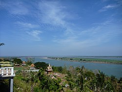
 View of Kampong Cham from Hanchey Temple | |
 Map of Cambodia highlighting Kampong Cham | |
| Coordinates: 11°59′N 105°27′E / 11.983°N 105.450°E | |
| Country | |
| Provincial status | 1 January 1885 |
| Capital | Kampong Cham Municipality |
| Area | |
| • Total | 4,549 km2 (1,756 sq mi) |
| Population (2019 census) | |
| • Total | |
| • Density | 197/km2 (510/sq mi) |
| Time zone | UTC+07 |
| Dialing code | +855 |
| ISO 3166 code | KH-3 |
| Districts | 10 |
| Communes | 109 |
| Villages | 916 |
Kampong Cham is a province (khaet) of Cambodia. Its capital and largest city is also named Kampong Cham.
Kampong Cham was divided into two provinces on 31 December 2013.[1][2] All land west of the Mekong River remained Kampong Cham. Land east of the river became Tboung Khmum Province.
There are 9 districts and 1 municipality:
- Batheay
- Chamkar Leu
- Cheung Prey
- Kampong Cham Municipality
- Kampong Siem
- Kang Meas
- Koh Sotin
- Prey Chhor
- Srey Santhor
- Steung Trang
References[change | change source]
- ↑ Mom, Kunthear; Kevin Ponniah (10 January 2014). "Kampong Cham's great divide". The Phnom Penh Post. Retrieved 29 January 2014.
- ↑ Phorn, Bopha; Alex Willemyns (10 January 2014). "Government Creates New CPP-Majority Province". The Cambodia Daily. Archived from the original on 2 February 2014. Retrieved 29 January 2014.
