Kujalleq
Kujalleq Municipality
Kommune Kujalleq | |
|---|---|
 | |
 Location of Kujalleq within Greenland | |
| Coordinates (Kujalleq Commune): 61°00′N 45°00′W / 61.000°N 45.000°W | |
| Sovereign state | |
| Country | |
| Municipality | Kujalleq |
| Established | 1 January 2009 |
| Municipal center | Qaqortoq |
| Government | |
| • Mayor | Kiista P. Isaksen (Siumut) |
| Area | |
| • Total | 32,000 km2 (12,355 sq mi) |
| Population (2022)[3] | |
| • Total | 6,292 |
| • Density | 0.197/km2 (0.51/sq mi) |
| Time zone | UTC-03 |
| Calling code | +299 |
| ISO 3166 code | GL-KU |
| Website | kujalleq.gl |
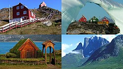
Kujalleq (Greenlandic: Greenlandic pronunciation: [kujaɬːɜq̚], Danish: Syden, lit. 'The South') is a municipality of Greenland. The largest settlement there is Qaqortoq.
References[change | change source]
- ↑ "Kommune Kujalleq". Kujalleq Municipality. Archived from the original on 7 January 2013. Retrieved 11 July 2010.
- ↑ Statistics Greenland, Greenland in Figures 2010
- ↑ "Population January 1st by municipality and time". Statistical Greenland. Retrieved 12 March 2022.[permanent dead link]


