La Union
La Union | |
|---|---|
| Province of La Union | |
(from top: left to right) San Fernando City, Beach in Agoo, Welcome arch at the La Union-Ilocos Sur border, rice field in Naguilian, Tapuakan River in Pugo | |
| Nickname: Elyu | |
| Motto(s): "Love, Union, Concord" | |
| Anthem: La Union Hymn | |
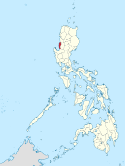
 Location in the Philippines | |
| Coordinates: 16°30′N 120°25′E / 16.5°N 120.42°E | |
| Country | Philippines |
| Region | Ilocos Region (Region I) |
| Founded | March 2, 1850 |
| Capital and largest city | San Fernando |
| Government | |
| • Governor | Raphaelle Veronica A. Ortega-David |
| • Vice Governor | Mario Eduardo C. Ortega (NUP) |
| • Legislature | La Union Provincial Board |
| Area | |
| • Total | 1,497.70 km2 (578.27 sq mi) |
| • Rank | 69th out of 81 |
| Highest elevation | 1,520 m (4,990 ft) |
| Population (2020 census) | |
| • Total | 822,352 |
| • Rank | 37th out of 81 |
| • Density | 550/km2 (1,400/sq mi) |
| • Rank | 9th out of 81 |
| Divisions | |
| • Independent cities | 0 |
| • Component cities | |
| • Municipalities | |
| • Barangays | 576 |
| • Districts | Legislative districts of La Union |
| Time zone | UTC+8 (PHT) |
| ZIP code | 2500–2520 |
| IDD : area code | +63 (0)72 |
| ISO 3166 code | PH-LUN |
| Languages | |
| Website | www |
La Union is a province in the Philippines. It is in the Ilocos Region. Its capital is the city of San Fernando, which is also the regional center of the Ilocos Region.
- ↑ "List of Provinces". PSGC Interactive. Makati City, Philippines: National Statistical Coordination Board. Archived from the original on 11 January 2013. Retrieved 30 July 2013.


