
Lebanon, Kansas
Lebanon, Kansas | |
|---|---|
 Visitor center (2019) | |
 Location within Smith County and Kansas | |
 | |
| Coordinates: 39°48′37″N 98°33′26″W / 39.81028°N 98.55722°W[1] | |
| Country | United States |
| State | Kansas |
| County | Smith |
| Founded | 1876 |
| Incorporated | 1889 |
| Named for | Lebanon, Kentucky |
| Government | |
| • Type | Mayor–Council |
| Area | |
| • Total | 0.32 sq mi (0.84 km2) |
| • Land | 0.32 sq mi (0.84 km2) |
| • Water | 0.00 sq mi (0.00 km2) |
| Elevation | 1,844 ft (562 m) |
| Population | |
| • Total | 178 |
| • Density | 560/sq mi (210/km2) |
| Time zone | UTC−6 (CST) |
| • Summer (DST) | UTC−5 (CDT) |
| ZIP Code | 66952 |
| Area code | 785 |
| FIPS code | 20-39100 |
| GNIS ID | 2395665[1] |
Lebanon is a city in Smith County, Kansas, United States, in the north central part of the state. The population was 178 at the 2020 census.[3]
References[change | change source]
- ↑ 1.0 1.1 1.2 U.S. Geological Survey Geographic Names Information System: Lebanon, Kansas
- ↑ "2020 U.S. Gazetteer Files". United States Census Bureau. Retrieved December 8, 2023.
- ↑ 3.0 3.1 "Lebanon city, Kansas". United States Census Bureau. Retrieved December 8, 2023.
Municipalities and communities of Smith County, Kansas, United States | ||
|---|---|---|
| Cities | 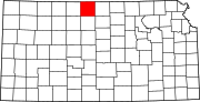 | |
| Unincorporated communities | ||
| Ghost towns | ||
| International | |
|---|---|
| National | |
| Geographic | |