Marathon, Greece
| Marathon Μαραθώνας | |
|---|---|
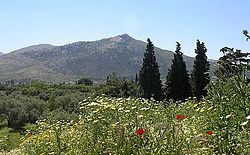
 The plain of Marathon today | |
| Location | |
| Time zone: | EET/EEST (UTC+2/3) |
| Elevation: | 0 m (0 ft) |
| Government | |
| Country: | Greece |
| Periphery: | Attica |
| Mayor: | Ilias Psinakis |
| Population statistics (as of 2011[1]) | |
| Municipality | |
| - Population: | 33,423 |
| - Area: | 222.75 km² (86 sq mi) |
| - Density: | 150 /km² (389 /sq mi) |
| Codes | |
| Postal: | 190 07 |
| Telephone: | 22940 |
| Auto: | Z |
| Website | |
| www.marathon.gr | |
Marathon (Demotic Greek: Μαραθώνας, Marathónas; Attic/Katharevousa: Μαραθών, Marathṓn) is a town in Greece and the site of the battle of Marathon around 490 BCE.
The name "Marathon" (Μαραθών) comes from the herb fennel, called marathon (μάραθον) or marathos (μάραθος) in Ancient Greek.[2][n 1] so Marathon literally means "a place full of fennels".[4]
Notes[change | change source]
References[change | change source]
- ↑ "(875 KB) 2001 Census" (PDF). National Statistical Service of Greece (ΕΣΥΕ) (in Greek). www.statistics.gr. Retrieved 2007-10-30.
- ↑ μάραθον. Liddell, Henry George; Scott, Robert; A Greek–English Lexicon at Perseus Project.
- ↑ "The Linear B word ma-ra-tu-wo". Palaeolexicon. Word study tool of Ancient languages. Raymoure, K.A. "ma-ra-tu-wo". Minoan Linear A & Mycenaean Linear B. Deaditerranean. Archived from the original on 2019-07-05. Retrieved 2020-03-01. "MY 602 Ge (57)". "MY 606 Ge + fr. (57)". "MY 605 Ge + 607 + fr. [+] 60Sa + fr. [+] 605b + frr. (57)". DĀMOS: Database of Mycenaean at Oslo. University of Oslo.
- ↑ Μαραθών in Liddell and Scott.

