Matterhorn
Appearance
| Matterhorn | |
|---|---|
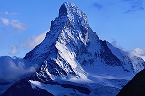
 East and north faces of the Matterhorn | |
| Highest point | |
| Elevation | 4,478 m (14,692 ft) |
| Prominence | 1042 m ↓ Col Durand[note 1] |
| Parent peak | Weisshorn |
| Isolation | 13.8 km → Liskamm-West Top[note 2] |
| Listing | Alpine four-thousanders Great north faces of the Alps |
| Coordinates | 45°58′35.0″N 7°39′31.0″E / 45.976389°N 7.658611°E[1] |
| Naming | |
| Native name | |
| English translation | Peak of the Meadows[2] |
| Geography | |
| Location | |
| Parent range | Pennine Alps |
| Topo map | swisstopo 1347 Matterhorn |
| Climbing | |
| First ascent |
|
| Easiest route | Hörnli ridge (AD, rock/mixed climb) |
The Matterhorn (in German; Italian: Cervino, French: Mont Cervin or Le Cervin) is ranked, by height, 12th mountain in the European Alps.[3] Its height is 4,478 metres.[4]
The mountain is on the border between Switzerland and Italy, it towers over the Swiss village of Zermatt and the Italian village Breuil-Cervinia in the Val Tournanche. The name of the mountain comes from the German words Matte, meaning valley or meadow, and Horn, which means peak.[5]
References
[change | change source]- ↑ "Commune Zermatt" (Map). Matterhorn peak (digital ed.). 1:10 0000. National Map 1:10'000. Wabern, Switzerland: Federal Office of Topography – swisstopo. Retrieved 2018-01-23 – via map.geo.admin.ch.
- ↑ Arnold Lunn, Matterhorn Centenary, Allen & Unwin, 1965 (p. 25)
- ↑ Even though the Matterhorn is very famous, both because of its beauty, and because it is hard to climb, it is not one of the 100 tallest mountains in the Alps. Several mountains near it, including Monte Rosa, the Dom, Liskamm and the Weisshorn, are taller.
- ↑ NHK, "Matterhorn: Majestic Peak that Pierces the Sky -- Switzerland, 4,478 m"; retrieved 2012-5-24.
- ↑ Swiss Mountains - Names www.swissworld.org Retrieved 26 November 2007.
- Charles Gos, Le Cervin (Attinger, 1948)
- Edward Whymper, Scrambles Amongst the Alps (1871)
Notes
- ↑ Despite its prominence in a local sense, the Matterhorn is not among the top 100 mountains in the Alps measured by topographic prominence. Its close neighbors Monte Rosa, the Dom, Liskamm and the Weisshorn, have higher summits. See a panoramic photograph of the view from Finsteraarhorn, to the north. The key col is Col Durand, at 3,436 metres (11,273 ft), between the Matterhorn and the Weisshorn.
- ↑ Retrieved from Google Earth. The nearest point of higher elevation is the Western Liskamm.
Other websites
[change | change source]Wikimedia Commons has media related to Matterhorn.
- Virtual ascent of the Hörnli Ridge with 360 degree panoramas Archived 2006-09-09 at the Wayback Machine
- Alpinist Magazine Archived 2007-10-17 at the Wayback Machine Mountain Profile - Issue 16
- Matterhorn Webcams Archived 2006-11-16 at the Wayback Machine
- Matterhorn on Summitpost
- PeakWare info on Matterhorn Archived 1999-10-13 at the Wayback Machine
- Matterhorn on 4000er.de
- Walt Disney and Zermatt
- Chronology of climbs - in German
- Photo gallery dedicated to Matterhorn and surrounding nature (in English)

