Mendocino County, California
Mendocino County, California | |
|---|---|
|
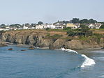
Images, from top down, left to right: The community of Mendocino, the historic Grace Hudson Sun House, Point Arena Lighthouse, the Chandelier Tree, the "Skunk Train", A beach in MacKerricher State Park | |
| Nickname: "Mendo" | |
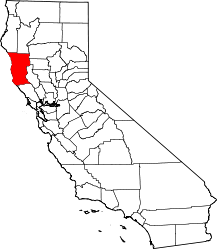
 Mendocino County's location within California | |
| Country | United States |
| State | California |
| Region | California North Coast |
| Incorporated | February 18, 1850[1] |
| Named for | Cape Mendocino, which was named for Andrés de Urdaneta |
| County seat | Ukiah |
| Largest city | Ukiah |
| Area | |
| • Total | 3,878 sq mi (10,040 km2) |
| • Land | 3,506 sq mi (9,080 km2) |
| • Water | 372 sq mi (960 km2) |
| Highest elevation | 6,958 ft (2,121 m) |
| Population | |
| • Total | 91,601 |
| • Density | 26/sq mi (10/km2) |
| Time zone | UTC−8 (Pacific Time Zone) |
| • Summer (DST) | UTC−7 (Pacific Daylight Time) |
| Area code | 707 |
| Website | www |
Mendocino County is a county in Northern California. The county seat is in Ukiah.
Towns in Mendocino County include:
- Fort Bragg
- Ukiah
- Willits
References[change | change source]
- ↑ "Chronology". California State Association of Counties. Archived from the original on 2015-02-06. Retrieved 2015-02-06.
- ↑ "Anthony Peak". Peakbagger.com. Archived from the original on 2015-05-02. Retrieved 2015-03-26.
- ↑ "QuickFacts - Mendocino County, California". United States Census Bureau.


