Mevaseret Zion
Appearance
31°48′N 35°9′E / 31.800°N 35.150°E
Mevaseret Zion
| |
|---|---|
| Hebrew transcription(s) | |
| • ISO 259 | Mbaśśert Çiyon |
| • Also spelled | Mevasseret Ziyyon (official) |
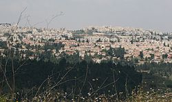
 View of Mevaseret from Rekhes Halilim | |
| Country | |
| District | |
| Founded | 1951 |
| Government | |
| • Type | Local council |
| • Head of Municipality | Yoram Shimon |
| Area | |
| • Total | 6,390 dunams (6.39 km2 or 2.47 sq mi) |
| Population (2022)[1] | |
| • Total | 25,487 |
| • Density | 4,000/km2 (10,000/sq mi) |
| Name meaning | Herald of Zion (from Isaiah 40:9) |
Mevaseret Zion (Hebrew: מְבַשֶּׂרֶת צִיּוֹן) is a suburb of Jerusalem with the administrative status of a local council. Mevaseret Zion is made up of two distinct older townships, Maoz Zion and Mevaseret Yerushalayim.
Mevaseret Zion is located on a mountain ridge 750 meters above sea level, on the outskirts of Jerusalem.
References
[change | change source]- ↑ "Regional Statistics". Israel Central Bureau of Statistics. Retrieved 21 March 2024.
Other websites
[change | change source]- Municipality website Archived 2013-12-29 at the Wayback Machine (in Hebrew)
- Harel High School website (in Hebrew)
- Notes on an Iron Age four sheqel scale weight from Mevasseret Yerushalayim
