Monroe, Washington
Monroe, Washington | |
|---|---|
 Main Street and Lewis Street in downtown Monroe | |
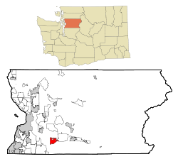
 Location of Monroe, Washington | |
| Coordinates: 47°51′28″N 121°59′18″W / 47.85778°N 121.98833°W | |
| Country | United States |
| State | Washington |
| County | Snohomish |
| Founded | 1864 |
| Incorporated | December 20, 1902 |
| Government | |
| • Type | Mayor–council |
| Area | |
| • Total | 6.16 sq mi (15.95 km2) |
| • Land | 6.10 sq mi (15.79 km2) |
| • Water | 0.06 sq mi (0.16 km2) |
| Elevation | 72 ft (22 m) |
| Population | |
| • Total | 19,699 |
| • Density | 3,243.56/sq mi (1,252.39/km2) |
| Time zone | UTC-8 (Pacific (PST)) |
| • Summer (DST) | UTC-7 (PDT) |
| ZIP code | 98272 |
| Area code | 360 |
| FIPS code | 53-46685 |
| GNIS feature ID | 1523319[3] |
| Website | ci.monroe.wa.us |
Monroe is a city in Snohomish County, Washington, United States.
References[change | change source]
- ↑ "2019 U.S. Gazetteer Files". United States Census Bureau. Retrieved August 7, 2020.
- ↑ "Explore Census Data". United States Census Bureau. Retrieved June 22, 2022.
- ↑ "Monroe, Washington". Geographic Names Information System. United States Geological Survey. September 10, 1979. Retrieved May 26, 2020.
