Mount Frissell
| Mount Frissell | |
|---|---|
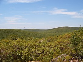
 Mount Frissell as seen from Bear Mountain | |
| Highest point | |
| Elevation | 2,454 ft (748 m)NAVD 88[1] |
| Prominence | 781 ft (238 m)[2] |
| Listing | U.S. state high points |
| Coordinates | 42°03′04″N 73°28′55″W / 42.051093558°N 73.481977744°W[1] |
| Geography | |
| Parent range | Taconic Mountains |
| Geology | |
| Age of rock | Ordovician |
| Mountain type | Thrust fault; metamorphic rock and sedimentary rock |
| Climbing | |
| Easiest route | Mount Frissel Trail |
Mount Frissell, 2,454 feet (748 m), is on the border of southwest Massachusetts and northwest Connecticut. It is a prominent peak of the Taconic Range. The peak and northern part of the mountain are in Massachusetts. The southern slope of Mount Frissell is in Connecticut, It rises to the highest elevation in that state, 2,379 feet (725 m). Bear Mountain, 1.3 miles (2.1 km) to the east, is the highest mountain summit in Connecticut.
The mountain is in the towns of Mount Washington, Massachusetts and Salisbury, Connecticut. A lot of the land is part of Massachusetts' Mount Washington State Forest and Connecticut's Mount Riga Forest Preserve. Mount Frissell is bordered by Round Mountain to the southeast, Mount Ashley to the north, and Brace Mountain to the west.
References[change | change source]
- ↑ 1.0 1.1 "Ryant Bush". NGS data sheet. U.S. National Geodetic Survey. Retrieved 2008-11-28.
- ↑ "Mount Frissell, Massachusetts". Peakbagger.com. Retrieved 2008-11-28.
Notes[change | change source]
- "Mount Frissell". Americasroof.com. Archived from the original on 2008-06-04. Retrieved 2008-11-28.
- Charles W. G. Smith, ed. (2004). Massachusetts Trail Guide. AMC Hiking Guide Series. Appalachian Mountain Club. ISBN 1-929173-44-X.

