
Ninh Bình province
(Redirected from Ninh Binh Province)
Ninh Bình province
Tỉnh Ninh Bình | |
|---|---|
 Ninh Bình province in Vietnam | |
| Country | |
| Area | |
| • Total | 1,387 km2 (536 sq mi) |
| Population (April 1, 2019) | |
| • Total | 982,487 |
| • Density | 708.4/km2 (1,835/sq mi) |
| Time zone | UTC+07:00 (ICT) |
| ISO 3166 code | VN-18 |
| Website | Official website |
Ninh Bình (![]() listen) is a province of Vietnam, in the Red River Delta region of the northern part of the country. Ninh Bình has a very short coastline on the Gulf of Tonkin. The population is 898,500 people. Ninh Bình province covers a total area of 1,329.4 square kilometres (513.3 sq mi). The province is known for its limestone caves and grottos (manmade caves).[1] Ninh Binh was the first imperial capital of Vietnam from 968 to 1010 under the Đinh, Lê and Lý dynasties.[1]
listen) is a province of Vietnam, in the Red River Delta region of the northern part of the country. Ninh Bình has a very short coastline on the Gulf of Tonkin. The population is 898,500 people. Ninh Bình province covers a total area of 1,329.4 square kilometres (513.3 sq mi). The province is known for its limestone caves and grottos (manmade caves).[1] Ninh Binh was the first imperial capital of Vietnam from 968 to 1010 under the Đinh, Lê and Lý dynasties.[1]
Gallery[change | change source]
-
 Limestone scenery
 -
 Rice paddies
 -
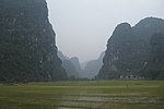
 Landscape near Ninh Bình
 -
 Tam Cốc-Bích Động
 -

-
 Hoa Lư - ancient capital
 -

-
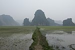
 Khê Hạ village and paddies


.jpg)

References[change | change source]
- ↑ 1.0 1.1 "Ninh Binh province – a huge tourism potential". Vietnam Beauty. 2 August 2008. Retrieved 26 January 2016.
Wikimedia Commons has media related to Ninh Binh.