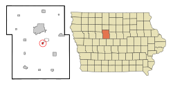
Otho, Iowa
Otho, Iowa | |
|---|---|
 Location of Otho, Iowa | |
| Coordinates: 42°25′29″N 94°8′59″W / 42.42472°N 94.14972°W | |
| Country | |
| State | |
| County | Webster |
| Government | |
| • Mayor | Duane Ferguston[1] |
| Area | |
| • Total | 0.44 sq mi (1.15 km2) |
| • Land | 0.44 sq mi (1.15 km2) |
| • Water | 0.00 sq mi (0.00 km2) |
| Elevation | 1,122 ft (342 m) |
| Population (2020) | |
| • Total | 429 |
| • Density | 968.40/sq mi (374.13/km2) |
| Time zone | UTC-6 (Central (CST)) |
| • Summer (DST) | UTC-5 (CDT) |
| ZIP code | 50569 |
| Area code | 515 |
| FIPS code | 19-60105 |
| GNIS feature ID | 0459915 |
Otho is a city in Iowa in the United States. According to 2020 census, 429 people were living in Otho.[3]
References[change | change source]
- ↑ "Bringing Otho together". Messenger News. Retrieved 12 November 2023.
- ↑ "2020 U.S. Gazetteer Files". United States Census Bureau. Retrieved March 16, 2022.
- ↑ "Otho city, Iowa Population By Ethnicity in Census 2020". beautifydata.com. Retrieved 2023-11-12.
