Pennsauken Township, New Jersey
Appearance
Pennsauken Township, New Jersey | |
|---|---|
| Motto(s): A Great Place to Grow, Dream and Prosper! | |
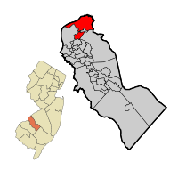
 Location of Pennsauken Township in Camden County highlighted in red (right). Inset map: Location of Camden County in New Jersey highlighted in orange (left). | |
 | |
| Coordinates: 39°58′06″N 75°03′29″W / 39.968392°N 75.057942°W[1][2] | |
| Country | |
| State | |
| County | Camden |
| Incorporated | February 18, 1892 |
| Government | |
| • Type | Township |
| • Body | Township Committee |
| Area | |
| • Total | 12.13 sq mi (31.41 km2) |
| • Land | 10.48 sq mi (27.14 km2) |
| • Water | 1.65 sq mi (4.27 km2) 13.59% |
| • Rank | 189th of 565 in state 5th of 37 in county[1] |
| Elevation | 89 ft (27 m) |
| Population | |
| • Total | 37,074 |
| • Rank | 66th of 565 in state 5th of 37 in county[7] |
| • Density | 3,537.9/sq mi (1,366.0/km2) |
| • Rank | 190th of 565 in state 23rd of 37 in county[7] |
| Time zone | UTC−05:00 (Eastern (EST)) |
| • Summer (DST) | UTC−04:00 (Eastern (EDT)) |
| ZIP Codes | |
| Area code[10] | 856 |
| FIPS code | 3400757660[1][11][12] |
| GNIS feature ID | 0882157[1][13] |
| Website | www |
Pennsauken is a township in Camden County, New Jersey, United States. It is a suburb of Philadelphia which is across the Delaware River. They are connected by the Betsy Ross Bridge.
The township includes Petty's Island, a 392-acre (1.59 km2) island in the Delaware River.
References
[change | change source]- ↑ 1.0 1.1 1.2 1.3 1.4 2019 Census Gazetteer Files: New Jersey Places, United States Census Bureau. Accessed July 1, 2020.
- ↑ US Gazetteer files: 2010, 2000, and 1990, United States Census Bureau. Accessed September 4, 2014.
- ↑ 2012 New Jersey Legislative District Data Book, Rutgers University Edward J. Bloustein School of Planning and Public Policy, March 2013, p. 38.
- ↑ U.S. Geological Survey Geographic Names Information System: Township of Pennsauken, Geographic Names Information System. Accessed March 8, 2013.
- ↑ QuickFacts Pennsauken township, Camden County, New Jersey, United States Census Bureau. Accessed February 9, 2023.
- ↑ Total Population: Census 2010 - Census 2020 New Jersey Municipalities, New Jersey Department of Labor and Workforce Development. Accessed December 1, 2022.
- ↑ 7.0 7.1 Population Density by County and Municipality: New Jersey, 2020 and 2021, New Jersey Department of Labor and Workforce Development. Accessed March 1, 2023.
- ↑ Look Up a ZIP Code for Pennsauken, NJ, United States Postal Service. Accessed July 24, 2012.
- ↑ Zip Codes, State of New Jersey. Accessed October 15, 2013.
- ↑ Area Code Lookup - NPA NXX for Pennsauken, NJ, Area-Codes.com. Accessed October 15, 2013.
- ↑ U.S. Census website, United States Census Bureau. Accessed September 4, 2014.
- ↑ Geographic codes for New Jersey, Missouri Census Data Center. Accessed April 1, 2022.
- ↑ US Board on Geographic Names, United States Geological Survey. Accessed September 4, 2014.


