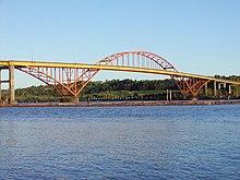
Port Mann Bridge
Appearance
Port Mann Bridge (2012) | |
|---|---|
 | |
| Coordinates | 49°13′16″N 122°48′46″W / 49.221031°N 122.812697°W |
| Carries | 10 lanes of British Columbia Highway 1 (Trans-Canada Highway), pedestrians and bicycles |
| Crosses | Fraser River |
| Locale | Coquitlam Surrey, British Columbia |
| Maintained by | Transportation Investment Corporation (TI Corp) |
| Preceded by | Port Mann Bridge (1965) |
| Characteristics | |
| Design | Cable-stayed bridge |
| Total length | 2,020 metres (6,630 ft) |
| Width | 65 metres (213 ft) |
| Height | 165 metres (541 ft) |
| Longest span | 470 metres (1,540 ft) |
| Clearance below | 40 metres (130 ft) |
| History | |
| Designer | T.Y. Lin International International Bridge Technologies |
| Construction start | February 6, 2009 |
| Construction end | September 18, 2015 |
| Construction cost | $825 million |
| Opened | September 18, 2012 (3 eastbound lanes) [1][2] November 17, 2012 (2 westbound lanes) [3] December 1, 2012 (4 lanes in each direction)[4] |
| Location | |
 | |
| References | |
| [5] | |
Port Mann Bridge (1965) | |
|---|---|
 | |
| Coordinates | 49°13′16″N 122°48′47″W / 49.221°N 122.813°W |
| Carries | 5 lanes of British Columbia Highway 1 (Trans-Canada Highway) |
| Crosses | Fraser River |
| Locale | Coquitlam Surrey, British Columbia |
| Maintained by | British Columbia Ministry of Transportation |
| Followed by | Port Mann Bridge (2nd, 2012) |
| Characteristics | |
| Design | Tied-arch bridge |
| Total length | 2090 m |
| Longest span | 368 m |
| History | |
| Designer | CBA Engineering |
| Constructed by | Dominion Bridge Company, John Laing and Sons, Perini Pacific, [6] Western Bridge & Steel[7] |
| Construction start | 1959[8][9][10] |
| Construction end | 1964 |
| Construction cost | $22.5 million |
| Opened | June 12, 1965 |
| Closed | November 18, 2012 (removed October 2015) |
| Location | |
 | |
The Port Mann Bridge is a 10-lane cable-stayed bridge, 90 km/h (55 mph) speed limit, in British Columbia, Canada, that opened to traffic in 2012. It carries 10 lanes of traffic with space for a light rail line.
The cable-stayed bridge replaced a steel arch bridge that spanned about 2 km over the Fraser River, connecting Coquitlam to Surrey in British Columbia in the Vancouver metro area. After its successor was opened to traffic, the old bridge was removed by reverse construction, a process which took 3 years to complete.
References[change | change source]
- ↑ News Staff (September 18, 2012). "3 eastbound lanes open on new Port Mann Bridge". CityNews. CityNews. Retrieved December 2, 2022.
- ↑ Nagel, Jeff (September 5, 2012). "Sept. 18 set for first crossings of new Port Mann". Peace Arch News. Peace Arch News. Retrieved December 2, 2022.
- ↑ Luba, Frank (November 13, 2012). "Drivers switch to new Port Mann Bridge as of this Saturday". Wilderness Committee. Wilderness Committee. Retrieved December 2, 2022.
- ↑ British Columbia Office of the Premier (December 1, 2012). "New Port Mann Bridge opens to eight lanes of traffic". British Columbia Government News. Government of British Columbia. Retrieved December 2, 2022.
- ↑ "Facts & Trivia". Pmh1project.com. Archived from the original on September 17, 2012. Retrieved December 7, 2012.
- ↑ British Columbia Department of Highways (1961). Minister of Highways Report for the Fiscal Year 1959/60 (Report). Victoria: Government of British Columbia. pp. 48 (F48), 49 (F49). doi:10.14288/1.0355809. J110.L5 S7; 1961_V01_10_F1_F124F. Retrieved December 2, 2022.
- ↑ British Columbia Department of Highways (1962). Minister of Highways Report for the Fiscal Year 1960/61 (Report). Victoria: Government of British Columbia. p. 62 (I 62). doi:10.14288/1.0363080. J110.L5 S7; 1962_V01_13_I1_I159. Retrieved December 2, 2022.
- ↑ "60 MPH to Hope in 1962". The Province. 18 July 1959. p. 29. ProQuest 2369054564.
The first multi-million dollar contract for the Port Mann crossing, 3 miles east of the Pattullo bridge, was awarded last week.
- ↑ "$7,295,000 Span Contract Awarded". The Province. 25 Aug 1959. p. 2. ProQuest 2369081808.
- ↑ "Bridge Pier Contract Let". The Sun. 26 Aug 1959. p. 20. ProQuest 2243691725.
Construction of the four-lane bridge is expected to begin within a week.
