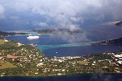
Port Vila
Port Vila | |
|---|---|
 Port Vila in November 2006 | |
| Coordinates: 17°43′59″S 168°19′0″E / 17.73306°S 168.31667°E | |
| Country | Vanuatu |
| Province | Shefa Province |
| Population (2020)[1] | |
| • Total | 49,034 |
Port Vila is the capital city of Vanuatu. Located on the south coast of the island of Efate, it has the country's most important dock and airport, Bauerfield International, making it the nation's economic and commercial center. As of the 2020 census, the population as 49,034.
During World War II, Port Vila was an American and Australian airbase. In 1987 and 2015, tropical cyclones badly damaged the city.
References[change | change source]
- ↑ "2020 National Population and Housing Census - Basic Tables Report, Volume 1, Version 2" (PDF). vnso.gov.vu. Vanuatu National Statistics Office. 2021-11-17. Retrieved 2023-09-05.


