Postville, Iowa
Postville, Iowa | |
|---|---|
| Motto: | |
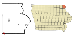
 Location of Postville, Iowa | |
| Coordinates: 43°5′6″N 91°34′10″W / 43.08500°N 91.56944°W | |
| Country | United States |
| State | Iowa |
| Counties | Allamakee, Clayton |
| Township | Post |
| Settled | June 1843 |
| Incorporated | March 11, 1873 |
| Area | |
| • Total | 2.08 sq mi (5.38 km2) |
| • Land | 2.08 sq mi (5.38 km2) |
| • Water | 0.00 sq mi (0.00 km2) |
| Elevation | 1,181 ft (360 m) |
| Population | |
| • Total | 2,503 |
| • Density | 1,205.10/sq mi (465.29/km2) |
| Time zone | UTC-6 (Central (CST)) |
| • Summer (DST) | UTC-5 (CDT) |
| ZIP code | 52162 |
| Area code | 563 |
| FIPS code | 19-64290 |
| GNIS feature ID | 0460373 |
| Website | www |
Postville is a city in Iowa in the United States.
References[change | change source]
- ↑ "City of Postville, Iowa - Hometown to the World". Cityofpostville.com. Retrieved 1 December 2015.
- ↑ Jones, Maggie (11 July 2012). "Postville, Iowa, Is Up for Grabs". Nytimes.com. Retrieved 8 February 2022.
- ↑ "2020 U.S. Gazetteer Files". United States Census Bureau. Retrieved March 16, 2022.
- ↑ "Postville city, Iowa". United States Census Bureau. Retrieved November 9, 2023.
Other websites[change | change source]
![]() Media related to Postville, Iowa at Wikimedia Commons
Media related to Postville, Iowa at Wikimedia Commons
- Official City Website
- Postville Community Schools Archived 2012-12-14 at the Wayback Machine
- City-Data Comprehensive Statistical Data and more about Postville
