Potosí Department
Department of Potosí | |
|---|---|
 Location within Bolivia | |
| Coordinates: 20°40′0″S 66°40′0″W / 20.66667°S 66.66667°W | |
| Country | |
| Capital | Potosí |
| Area | |
| • Total | 118,218 km2 (45,644 sq mi) |
| Population (2012) | |
| • Total | 823,517 |
| • Density | 7.0/km2 (18/sq mi) |
| Time zone | UTC-4 (BOT) |
Potosí is a department in Bolivia.[1] The capital city is also named Potosí.
Provinces[change | change source]
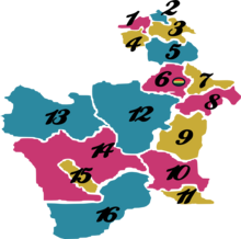
The department is divided into 16 provinces which are further divided into 40 municipalities [2] and then 219 cantons.
| Province | Capital | Area km² | Population (2012 census) |
Map Number |  |
|---|---|---|---|---|---|
| Alonso de Ibáñez | Sacaca | 2.170 | 29.821 | 1 | |
| Antonio Quijarro | Uyuni | 14,890 | 54,947 | 12 | |
| Bernardino Bilbao | Arampampa | 640 | 10,224 | 2 | |
| Charcas | San Pedro de Buena Vista | 2,964 | 41,214 | 3 | |
| Chayanta | Colquechaca | 7,026 | 97,251 | 5 | |
| Cornelio Saavedra | Betanzos | 2,375 | 55,100 | 7 | |
| Daniel Campos | Llica | 12,106 | 5,850 | 13 | |
| Enrique Baldivieso | San Agustín | 2,254 | 1,684 | 15 | |
| José María Linares | Puna | 5,136 | 49,619 | 8 | |
| Modesto Omiste | Villazón | 2,260 | 44,645 | 11 | |
| Nor Chichas | Cotagaita | 8,979 | 42,248 | 9 | |
| Nor Lípez | Colcha K | 20,892 | 14,057 | 14 | |
| Rafael Bustillo | Uncía | 2,235 | 86,947 | 4 | |
| Sud Chichas | Tupiza | 8,516 | 55,879 | 10 | |
| Sud Lípez | San Pablo de Lípez | 22,355 | 6,835 | 16 | |
| Tomás Frías | Potosí | 3,420 | 229,047 | 6 |
Places of interest[change | change source]
- Eduardo Avaroa Andean Fauna National Reserve
- Torotoro National Park
- Laguna Colorada
- Laguna Verde
- Laguna Blanca
- Salar de Uyuni
- Potosí
- Uyuni
Notable people[change | change source]
- Juana Azurduy de Padilla, guerrilla military leader
- Manuel Ascencio Padilla, namesake of the town of Padilla, Bolivia
- Modesto Omiste Tinajeros, writer, politician, and namesake of the province Modesto Omiste
References[change | change source]
- ↑ "The World Factbook". CIA. Archived from the original on 2018-12-25. Retrieved 2020-03-28.
- ↑ www.bolivia.com (English)


