Province of Belluno
Province of Belluno | |
|---|---|
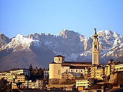
 The city of Belluno with the Schiara mountain | |
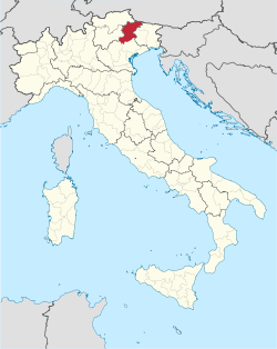
 Map with the province of Belluno, in red, in Italy | |
| Coordinates: 46°08′27″N 12°32′56″E / 46.14083°N 12.54889°E | |
| Country | Italy |
| Region | Veneto |
| Capital | Belluno |
| Comuni | 64 |
| Government | |
| • President | Daniela Larese Filon |
| Area | |
| • Total | 3,672.26 km2 (1,417.87 sq mi) |
| Population (1 January 2016)[3] | |
| • Total | 206,856 |
| • Density | 56/km2 (150/sq mi) |
| Time zone | UTC+1 (CET) |
| • Summer (DST) | UTC+2 (CEST) |
| Postal code | 32100 |
| Telephone prefix | 0437 |
| ISO 3166 code | IT-BL |
| Vehicle registration | BL |
| ISTAT | 025 |
| Website | Official website |
The Province of Belluno (Italian: Provincia di Belluno; German: Provinz Belluno) is a province in the Veneto region of Italy. Its capital is the city of Belluno.
Geography
[change | change source]The province of Belluno has an area of 3,672.26 square kilometres (1,417.87 square miles) and is the most northern of the provinces of the Veneto region, and is almost entirely occupied by mountain areas. In the eastern part of the province are the Dolomites, part of the eastern Alps, with high mountains, including the highest point of the province and of the region, the Marmolada (46°26′4″N 11°51′5″E / 46.43444°N 11.85139°E) that is 3,342 m (10,965 ft) high.[4]
The province is rich in water, with the presence of the wide Piave river that flows through the province from north to south.
The southern part of the province is called Valbelluna, the widest and most populous valley of the province.

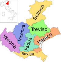
The province of Belluno borders to the north with Austria (Tyrol and Carinthia), to the east with the Friuli Venezia Giulia region (Udine and Pordenone provinces), to the south with the Treviso and Vicenza provinces) and to the west and northwest with the Trentino-Alto Adige/Südtirol region (Trento and South Tyrol provinces).
Population
[change | change source]As of 1 January 2016[update], there are 206,856 persons living in the province,[3] for a population density of 56.3 inhabitants/km².
Evolution of the population in the Belluno province

Language minorities
[change | change source]In the province, there are two language minorities, which are now recognized by law:
- a Ladin (a Romance language) minority is present in the three communes of Colle Santa Lucia, Livinallongo del Col di Lana and Cortina d'Ampezzo.
- a German-speaking minority in the commune of Sappada, Farra d'Alpago and Tambre.
Municipalities
[change | change source]There are 64 municipalities (or comuni) in the province; they are:
- Agordo
- Alano di Piave
- Alleghe
- Alpago
- Arsiè
- Auronzo di Cadore
- Belluno
- Borca di Cadore
- Calalzo di Cadore
- Canale d'Agordo
- Cencenighe Agordino
- Cesiomaggiore
- Chies d'Alpago
- Cibiana di Cadore
- Colle Santa Lucia
- Comelico Superiore
- Cortina d'Ampezzo
- Danta di Cadore
- Domegge di Cadore
- Falcade
- Feltre
- Fonzaso
- Gosaldo
- La Valle Agordina
- Lamon
- Lentiai
- Limana
- Livinallongo del Col di Lana
- Longarone
- Lorenzago di Cadore
- Lozzo di Cadore
- Mel
- Ospitale di Cadore
- Pedavena
- Perarolo di Cadore
- Pieve di Cadore
- Ponte nelle Alpi
- Quero Vas
- Rivamonte Agordino
- Rocca Pietore
- San Gregorio nelle Alpi
- San Nicolò di Comelico
- San Pietro di Cadore
- San Tomaso Agordino
- San Vito di Cadore
- Santa Giustina
- Santo Stefano di Cadore
- Sappada
- Sedico
- Selva di Cadore
- Seren del Grappa
- Sospirolo
- Soverzene
- Sovramonte
- Taibon Agordino
- Tambre
- Trichiana
- Val di Zoldo
- Vallada Agordina
- Valle di Cadore
- Vigo di Cadore
- Vodo di Cadore
- Voltago Agordino
- Zoppè di Cadore
Largest municipalities
[change | change source]The following shows the 10 comuni with the population,[3] and the area and altitude.[5]
| No. | Comune | Population (2016) |
Area (km²) |
Density | Altitude (m) |
|---|---|---|---|---|---|
| 1 | Belluno | 35,870 | 147.22 | 243.6 | 383 |
| 2 | Feltre | 20,649 | 99.79 | 206.9 | 325 |
| 3 | Sedico | 9,997 | 91.20 | 109.6 | 317 |
| 4 | Ponte nelle Alpi | 8,363 | 58.14 | 143.8 | 397 |
| 5 | Alpago | 6,994 | 80.34 | 87.1 | 690 |
| 6 | Santa Giustina | 6,807 | 35.92 | 189.5 | 308 |
| 7 | Mel | 5,984 | 86.24 | 69.4 | 352 |
| 8 | Cortina d'Ampezzo | 5,907 | 252.81 | 23.4 | 1,211 |
| 9 | Longarone | 5,359 | 122.36 | 43.8 | 473 |
| 10 | Limana | 5,209 | 39.12 | 133.2 | 319 |
Gallery
[change | change source]-
Overview of Belluno.
-
Palazzo dei Rettori, Belluno.
-
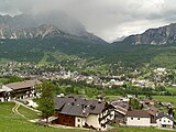
Cortina d'Ampezzo.
-
Pedavena, Belluno province.
References
[change | change source]- ↑ "Chi governa" (in Italian). Provincia di Belluno. Retrieved 6 April 2017.
- ↑ "Provincia di Belluno" (in Italian). Tuttitalia.it. Retrieved 6 April 2017.
- ↑ 3.0 3.1 3.2 "Statistiche demografiche ISTAT" (in Italian). Demo.istat.it. Archived from the original on 26 June 2017. Retrieved 6 April 2017.
- ↑ "Marmolada, Italy". Peakbagger.com. Retrieved 6 April 2017.
- ↑ "Comuni in provincia di Belluno per popolazione" (in Italian). Tuttitalia.it. Retrieved 7 April 2017.
Other websites
[change | change source]- Provincia di Belluno Official site (in Italian)


