
Punta Arenas
Punta Arenas
Sandy Point, Magallanes | |
|---|---|
 Montage of Punta Arenas | |
|
 Coat of arms   Punta Arenas Location in Chile | |
| Coordinates (city): 53°10′S 70°56′W / 53.167°S 70.933°W | |
| Country | |
| Region | |
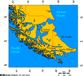
| Province | Magallanes |
| Founded as | Punta Arenas |
| Foundation | 18 December 1848 |
| Government | |
| • Type | Municipality |
| • Alcalde | Claudio Radonich (National Renewal) |
| Area | |
| • Total | 17,846.3 km2 (6,890.5 sq mi) |
| Elevation | 34 m (112 ft) |
| Population (2012 Census)[3] | |
| • Total | 127,454 |
| • Density | 7.1/km2 (18/sq mi) |
| • Urban | 116,005 |
| • Rural | 3,491 |
| Demonym | Puntarenian |
| Sex | |
| • Men | 60,616 (2002) |
| • Women | 58,880 (2002) |
| Time zone | UTC−4 (CLT) |
| • Summer (DST) | UTC-3 (CLST) |
| Area code | 56 + 61 |
| Climate | Cfc |
| Website | Official website (in Spanish) |
Punta Arenas (lit. Sandy Point) is the capital of Magallanes y Antártica Chilena Region and the largest city in the region. It has the 1% (about 124246 people) of the total population. It is located at comuna (municipality) of Magallanes, and geographically at Brunswich Peninsula (53° 10' S 70° 56'W).
Images[change | change source]
-
 Punta Arenas
 -
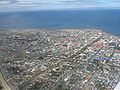
 Punta Arenas at north shore of strait of Magallanes
 -
 Strait of Magallanes at Punta Arenas


References[change | change source]
- ↑ "Asociación Chilena de Municipalidades" (in Spanish). Retrieved 27 January 2011.
- ↑ "Municipality of Punta Arenas" (in Spanish). Retrieved 27 January 2011.
- ↑ 3.0 3.1 3.2 "National Statistics Institute" (in Spanish). Retrieved 27 January 2010.
Other websites[change | change source]
| International | |
|---|---|
| National | |
| Geographic | |
| Other | |