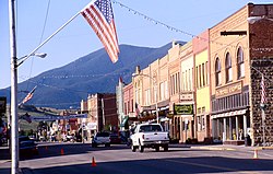
Red Lodge, Montana
Red Lodge, Montana | |
|---|---|
 Main Street (2000) | |
 Location within Carbon County and Montana | |
| Coordinates: 45°11′15″N 109°14′55″W / 45.18750°N 109.24861°W[1] | |
| Country | United States |
| State | Montana |
| County | Carbon |
| Area | |
| • Total | 2.71 sq mi (7.03 km2) |
| • Land | 2.71 sq mi (7.03 km2) |
| • Water | 0.00 sq mi (0.00 km2) |
| Elevation | 5,588 ft (1,703 m) |
| Population | |
| • Total | 2,257 |
| • Density | 832.23/sq mi (321.27/km2) |
| Time zone | UTC-7 (Mountain (MST)) |
| • Summer (DST) | UTC-6 (MDT) |
| ZIP code | 59068 |
| Area code | 406 |
| FIPS code | 30-61525 |
| GNIS ID | 2411529[1] |
| Website | cityofredlodge.net |
Red Lodge is a city in Montana in the United States. It is the county seat of Carbon County. As of the 2020 United States Census, there were 2,257 people.[3]
Red Lodge is a gateway to Yellowstone National Park via the Beartooth Highway.
References[change | change source]
- ↑ 1.0 1.1 1.2 U.S. Geological Survey Geographic Names Information System: Red Lodge, Montana
- ↑ "ArcGIS REST Services Directory". United States Census Bureau. Retrieved September 5, 2022.
- ↑ 3.0 3.1 "Profile of General Population and Housing Characteristics: 2020 Demographic Profile Data (DP-1): Red Lodge city, Montana". United States Census Bureau. Retrieved February 22, 2024.
