Romoland, California
Romoland | |
|---|---|
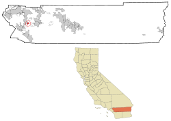
 Location in Riverside County and the state of California | |
| Coordinates: 33°44′45″N 117°10′30″W / 33.74583°N 117.17500°W[1] | |
| Country | United States |
| State | California |
| County | Riverside |
| Area | |
| • Total | 2.644 sq mi (6.849 km2) |
| • Land | 2.644 sq mi (6.849 km2) |
| • Water | 0 sq mi (0 km2) 0% |
| Elevation | 1,444 ft (440 m) |
| Population (2020)[3] | |
| • Total | 2,005 |
| • Density | 760/sq mi (290/km2) |
| Time zone | UTC-8 (PST) |
| • Summer (DST) | UTC-7 (PDT) |
| ZIP code | 92585 |
| Area code | 951 |
| FIPS code | 06-62756 |
| GNIS feature ID | 1661327 |
Romoland is a census-designated place (CDP) in Riverside County, California, United States. The population was 2,005 at the 2020 census.[3]
References[change | change source]
- ↑ 1.0 1.1 "Romoland". Geographic Names Information System. United States Geological Survey. Retrieved November 11, 2014.
- ↑ "2010 Census U.S. Gazetteer Files – Places – California". United States Census Bureau.
- ↑ 3.0 3.1 "Romoland CDP, California". United States Census Bureau. Retrieved August 30, 2023.


