
Shikotsu-Tōya National Park
| Shikotsu-Tōya National Park | |
|---|---|
| 支笏洞爺国立公園 | |
IUCN category II (national park) | |
 Lake Tōya (October 2007) | |
 Location of Shikotsu-Tōya National Park in Japan | |
| Location | Hokkaidō, Japan |
| Coordinates | 42°40′N 141°0′E / 42.667°N 141.000°E |
| Area | 993.02 km2 (383.41 sq mi) |
| Established | May 16, 1949 |
| Governing body | Ministry of the Environment |
Shikotsu-Tōya National Park (In Japanese:支笏洞爺国立公園, Shikotsu Tōya kokuritsu Kōen) is a national Park that is in the western part of the island of Hokkaidō in Japan. The total area is estimated to be 993.02 Square Kilometres.
Gallery[change | change source]
-
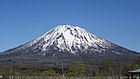
 Mount Tarumae as seen from Lake Shikotsu
 -
-
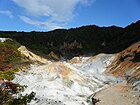 Noboribetsu hot spring
 -


Other websites[change | change source]
 Media related to Shikotsu-Toya National Park at Wikimedia Commons
 Shikotsu-Tōya National Park travel guide from Wikivoyage
- Shikotsu-Toya National Park Habitat Center of Japan
- Tōya Usu Geopark (English, Japanese)