
St. Helena, California
St. Helena, California | |
|---|---|
  .jpg) 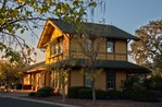 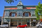 Clockwise: The Culinary Institute of America at Greystone; V. Sattui Winery; the Richie Block downtown; former train depot; Beringer Vineyards | |
| Motto(s): "Napa Valley's Main Street",[1] | |
 Location in Napa County and the state of California | |
| Coordinates: 38°30′19″N 122°28′13″W / 38.50528°N 122.47028°W | |
| Country | United States |
| State | California |
| County | Napa |
| Incorporated | March 24, 1876[2] |
| Re-incorporated | May 14, 1889[3] |
| Area | |
| • City | 5.08 sq mi (13.16 km2) |
| • Land | 4.96 sq mi (12.83 km2) |
| • Water | 0.13 sq mi (0.33 km2) 0.81% |
| Elevation | 253 ft (77 m) |
| Population | |
| • City | 5,430 |
| • Density | 1,231.5/sq mi (475.49/km2) |
| Time zone | UTC-8 (Pacific) |
| • Summer (DST) | UTC-7 (PDT) |
| ZIP code | 94574 |
| Area code | 707 |
| FIPS code | 06-64140 |
| GNIS feature IDs | 277588, 2411758 |
| Website | www |
St. Helena (/həˈliːnə/ hə-LEE-nə; Wappo: Anakotanoma, "Bull Snake Village") is a city in Napa County, California. The population was 5,430 at the 2020 census.[6]
References[change | change source]
- ↑ "ST. HELENA NAPA VALLEY'S MAIN STREET Trademark". Alter.com. Archived from the original on March 31, 2023. Retrieved January 23, 2015.
- ↑ "California Cities by Incorporation Date". California Association of Local Agency Formation Commissions. Archived from the original (Word) on November 3, 2014. Retrieved August 25, 2014.
- ↑ "About St. Helena". City of St. Helena. Archived from the original on February 27, 2017. Retrieved January 23, 2015.
- ↑ "2019 U.S. Gazetteer Files". United States Census Bureau. Retrieved July 1, 2020.
- ↑ "Saint Helena". Geographic Names Information System. United States Geological Survey. Retrieved February 25, 2015.
- ↑ 6.0 6.1 "QuickFacts: St. Helena city, California". United States Census Bureau. Retrieved August 25, 2023.
Municipalities and communities of Napa County, California, United States | ||
|---|---|---|
| Cities and towns |  | |
| CDPs | ||
| Unincorporated communities | ||
| Ghost towns | ||