Streetman, Texas
Streetman, Texas | |
|---|---|
 | |
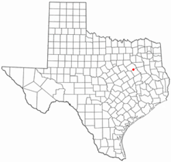
 Location of Streetman, Texas | |
 | |
| Coordinates: 31°52′37″N 96°19′28″W / 31.87694°N 96.32444°W | |
| Country | United States |
| State | Texas |
| Counties | Freestone, Navarro |
| Area | |
| • Total | 1.41 sq mi (3.64 km2) |
| • Land | 1.40 sq mi (3.63 km2) |
| • Water | 0.00 sq mi (0.01 km2) |
| Elevation | 371 ft (113 m) |
| Population | |
| • Total | 248 |
| • Density | 176.76/sq mi (68.25/km2) |
| Time zone | UTC-6 (Central (CST)) |
| • Summer (DST) | UTC-5 (CDT) |
| ZIP code | 75859 |
| Area code | 903 |
| FIPS code | 48-70604[3] |
| GNIS feature ID | 1347998[4] |
Streetman is a town in the U.S. state of Texas.
References[change | change source]
- ↑ "2019 U.S. Gazetteer Files". United States Census Bureau. Retrieved August 7, 2020.
- ↑ "Profile of General Population and Housing Characteristics: 2020 Demographic Profile Data (DP-1): Streetman town, Texas". United States Census Bureau. Retrieved February 9, 2024.
- ↑ "U.S. Census website". United States Census Bureau. Retrieved 2008-01-31.
- ↑ "US Board on Geographic Names". United States Geological Survey. 2007-10-25. Retrieved 2008-01-31.
