Tataouine Governorate
Appearance
Tataouine
تطاوين | |
|---|---|
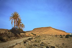
 Moonlit landscape of Tataouine | |
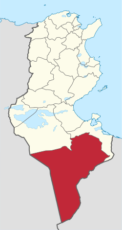
 Map of Tunisia with Tataouine highlighted | |
| Coordinates: 32°55′32″N 10°26′39″E / 32.92556°N 10.44417°E | |
| Country | Tunisia |
| Created | March 2, 1981[1] |
| Capital | Tataouine |
| Area | |
| • Total | 38,889 km2 (15,015 sq mi) |
| • Rank | Ranked 1st of 24 |
| Population (2014) | |
| • Total | 149,453 |
| • Rank | Ranked 23rd of 24 |
| • Density | 3.8/km2 (10.0/sq mi) |
| Time zone | UTC+01 (CET) |
| Postal prefix | xx |
| ISO 3166 code | TN-83 |
Tataouine Governorate (Tunisian Arabic: ولاية تطاوين Wilāyat Taṭāwīn) is one of the twenty-four governorates of Tunisia. It is in the southern part of the country, the only one to border both Algeria and Libya. It is also the largest governorate of the country by area. It covers an area of 38,889 km².[1] As of the 2014 census, 149,453 people lived there.[2][3] The capital is Tataouine.
References
[change | change source]- ↑ 1.0 1.1 (in French) "tunisieindustrie.nat.tn". Archived from the original on 2009-02-17.
- ↑ "2014 Tunisian census data". Archived from the original on 2015-05-18.
- ↑ (in French) Census 2014 (National Institute of Statistics) Archived 2014-10-29 at the Wayback Machine
