
Temuco
Temuco | |
|---|---|
 | |
 Coat of arms | |
 Map of Temuco commune in Araucanía Region | |
| Coordinates: 38°44′S 72°40′W / 38.733°S 72.667°W | |
| Country | Chile |
| Region | Araucanía |
| Province | Cautín |
| Founded | 24 February 1881 |
| Government | |
| • Type | Municipality |
| • Alcalde | Miguel Becker Alvear (RN) |
| Area | |
| • Total | 464 km2 (179 sq mi) |
| Population (2002 Census)[3] | |
| • Total | 245,347 |
| • Density | 530/km2 (1,400/sq mi) |
| • Urban | 232,528 |
| • Rural | 12,819 |
| Sex | |
| • Men | 117,071 |
| • Women | 128,276 |
| Time zone | UTC−4 (CLT) |
| • Summer (DST) | UTC−3 (CLST) |
| Area code | 56 + 45 |
| Website | Municipality of Temuco |
Temuco is a Chilean city with 245,347 inhabitants (2002 census).
History[change | change source]
Temuco was founded by Manuel Recabarren naming the place Fuerte Recabarren(Fort Recabarren) during the Occupation of Araucania on 1881.
Gallery[change | change source]
-
 The Bus Station of Temuco
 -
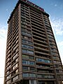 Caupolicán Tower
 -
 Skyline of Temuco


References[change | change source]
- ↑ (in Spanish) "Asociación Chilena de Municipalidades". Archived from the original on 4 May 2019. Retrieved 7 February 2011.
- ↑ (in Spanish) "Municipality of Temuco". Archived from the original on 4 May 2019. Retrieved 7 February 2011.
- ↑ 3.0 3.1 3.2 (in Spanish) "National Statistics Institute". Retrieved 13 December 2010.
Other websites[change | change source]
- Temuco municipality Archived 2019-05-04 at the Wayback Machine (in Spanish)
Wikimedia Commons has media related to Temuco.