Villars, Vaucluse
Appearance
Villars | |
|---|---|
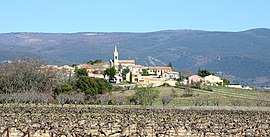
 A view of Villars with vineyards | |
| Coordinates: 43°55′27″N 5°24′22″E / 43.9241666667°N 5.40611111111°E | |
| Country | France |
| Region | Provence-Alpes-Côte d'Azur |
| Department | Vaucluse |
| Arrondissement | Apt |
| Canton | Apt |
| Government | |
| • Mayor (2008–2014) | Alain Massel |
| Area 1 | 30.05 km2 (11.60 sq mi) |
| Population (1999) | 686 |
| • Density | 23/km2 (59/sq mi) |
| Time zone | UTC+01:00 (CET) |
| • Summer (DST) | UTC+02:00 (CEST) |
| INSEE/Postal code | 84145 /84400 |
| Elevation | 247–1,184 m (810–3,885 ft) (avg. 300 m or 980 ft) |
| 1 French Land Register data, which excludes lakes, ponds, glaciers > 1 km2 (0.386 sq mi or 247 acres) and river estuaries. | |
Villars, Vaucluse is a commune. It is found in the region Provence-Alpes-Côte d'Azur in the Vaucluse department in the south of France.
Wikimedia Commons has media related to Villars (Vaucluse).


