
Vitacura
Vitacura | |
|---|---|
|
Emblem | |
 Map of the Vitacura commune within Greater Santiago | |
| Coordinates (city): 33°23′00″S 70°34′30″W / 33.38333°S 70.57500°W | |
| Country | Chile |
| Region | Santiago Metro. |
| Province | Santiago |
| Founded | 9 March 1981 |
| Government | |
| • Type | Municipality |
| • Alcalde | Raúl Torrealba Del Pedregal (RN) |
| Area | |
| • Total | 28.3 km2 (10.9 sq mi) |
| Population (2002 Census)[3] | |
| • Total | 81,499 |
| • Density | 2,900/km2 (7,500/sq mi) |
| • Urban | 81,499 |
| • Rural | 0 |
| Sex | |
| • Men | 35,118 |
| • Women | 46,381 |
| Time zone | UTC-4 (CLT [4]) |
| • Summer (DST) | UTC-3 (CLST [5]) |
| Area code | 56 + |
| Website | Municipality of Vitacura |
Vitacura is a commune and city of Santiago Province, Chile. According to the Chilean census on 2002, Vitacura has an area of 28.3 square kilometres (10.9 sq mi) and 81,499 inhabitants.
History
[change | change source]The name of this city is in honor to the cacique called Vitacura who was collaborator of the Spanish conqueror Pedro de Valdivia.
Gallery
[change | change source]-
 Emblem logo
 -
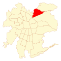 Location in Santiago of Chile
 -
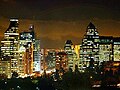 Skyline at night
 -
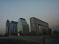 Shopping Center
 -
 A elegant liquor store


References
[change | change source]- ↑ "Asociación Chilena de Municipalidades". Retrieved 27 January 2011. (in Spanish)
- ↑ "Municipality of Vitacura". Retrieved 27 January 2011.(in Spanish)
- ↑ 3.0 3.1 3.2 "National Statistics Institute". Retrieved 3 December 2010. (in Spanish)
- ↑ "Chile Time". WorldTimeZones.org. Archived from the original on 2007-09-11. Retrieved 2010-07-29.
- ↑ "Chile Summer Time". WorldTimeZones.org. Archived from the original on 2007-09-11. Retrieved 2010-07-29.
Other websites
[change | change source]Wikimedia Commons has media related to Vitacura.
- Municipality of Vitacura (in Spanish)