Wachau
| UNESCO World Heritage Site | |
|---|---|
 | |
| Location | Lower Austria, Austria |
| Criteria | Cultural: (ii)(iv) |
| Reference | 970 |
| Inscription | 2000 (24th Session) |
| Area | 18,387 ha (45,440 acres) |
| Buffer zone | 2,942 ha (7,270 acres) |
| Website | www |
| Coordinates | 48°21′52″N 15°26′3″E / 48.36444°N 15.43417°E |
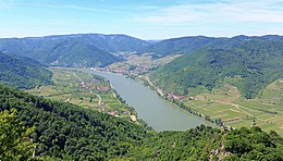
The Wachau is an Austrian valley. It has pretty landscape formed by the Danube river. It is one of the biggest tourist places of Lower Austria. It is midway between the towns of Melk and Krems. It is 40 kilometres (25 mi) in length. People lived here in prehistoric times.
A well-known place and tourist attraction is Dürnstein. This is where King Richard the Lion-Heart of England was held captive by Duke Leopold V.
The Wachau is a UNESCO World Heritage Site. This is for its architectural and agricultural history.[1][2]
References[change | change source]
- ↑ "Wachau Cultural Landscape". Unseco.org. Retrieved December 5, 2010.
- ↑ "United Nations Educational, Scientific And Cultural Organization Convention Concerning The Protection Of The World Cultural And Natural Heritage, World Heritage Committee:Twenty-fourth session, Cairns, Australia:27 November – 2 December 2000: Report". Unesco.org. Retrieved December 5, 2010.

