Walden, New York
Walden, New York | |
|---|---|
 Central Walden, with memorials and St. Andrew's Episcopal Church, in 2007 | |
| Etymology: From Jacob T. Walden[1] | |
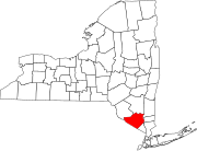
 Location in Orange County and the state of New York. | |
 Location of New York in the United States | |
| Coordinates: 41°33′36″N 74°11′23″W / 41.56000°N 74.18972°W | |
| Country | United States |
| State | New York |
| County | Orange |
| Town | Montgomery |
| Government | |
| • Body | Village board |
| Area | |
| • Total | 2.08 sq mi (5.40 km2) |
| • Land | 2.01 sq mi (5.20 km2) |
| • Water | 0.07 sq mi (0.19 km2) |
| Elevation | 260 ft (80 m) |
| Population | |
| • Total | 6,818 |
| • Density | 3,393.7/sq mi (1,310.4/km2) |
| Time zone | UTC-5 (Eastern) |
| • Summer (DST) | UTC-4 (Eastern Daylight Time) |
| ZIP Code | 12586 |
| Area code | 845 |
| Exchanges | 778, 787 |
| FIPS code | 36-77849 |
| Website | https://www.villageofwalden.org/ |
Walden is the largest of three villages of the Town of Montgomery in Orange County, New York, United States. The population was 6,818 at the 2020 census.[3]
References[change | change source]
- ↑ Eager, Samuel Watkins (1846). An Outline History of Orange County: Together with Local Tradition and Short Biographical Sketches of Early Settlers, Etc. T. E. Henderson. p. 273.
- ↑ "ArcGIS REST Services Directory". United States Census Bureau. Retrieved September 20, 2022.
- ↑ 3.0 3.1 "QuickFacts: Walden village, New York". United States Census Bureau. Retrieved March 11, 2024.

