West Hills, Los Angeles
West Hills | |
|---|---|
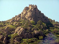
 Escorpión Peak (aka: Castle Peak) (1,475 feet/450 m)—east face view from West Hills. | |
 West Hills as delineated by the Los Angeles Times | |
| Coordinates: 34°12′14″N 118°37′44″W / 34.204°N 118.629°W | |
| Country | United States |
| State | California |
| County | Los Angeles |
| City | Los Angeles |
| Owensmouth | 1912 |
| Canoga Park | 1930 |
| West Hills | 1987 |
| Area | |
| • Total | 8.53 sq mi (22 km2) |
| Elevation | 900 ft (274 m) |
| Population (2008)[1] | |
| • Total | 41,426 |
| • Density | 4,551/sq mi (1,757/km2) |
| Time zone | UTC-8 (PST) |
| • Summer (DST) | UTC-7 |
| ZIP code | 91304 & 91307 |
| Area code | 818 & 747 |
West Hills, Los Angeles is a neighborhood of Los Angeles, California.[2][3] The percentage of residents aged 35 and older is among the highest in Los Angeles County.[4]
Notable residents[change | change source]
- Blake Gailen (born 1985) – American-Israeli baseball player[5][6]
- Jesse James Hollywood – convicted of kidnapping and murder[7]
- Francis Lederer — actor, early film star, civic leader
- Miguel Leonis — 19th century owner of Rancho El Escorpión
- Nicholas Markowitz — victim in Jesse James Hollywood kidnapping-murder case
- Bob Miller (sports announcer) — play-by-play broadcaster
- Christopher Mintz-Plasse — actor
- Daniella Monet — actress
- Daniel Olivas — author, book critic, attorney
- Kevin Pillar — professional baseball outfielder[8]
- Mark Saul — actor
- America Ferrera — actress
- Frank Kelly Freas — science fiction illustrator
References[change | change source]
- ↑ "LAtimes.com/Mapping-L.A. neighborhoods/West Hills . accessed 8.18.2011". Archived from the original on 2013-06-10. Retrieved 2015-08-21.
- ↑ [1][permanent dead link] Median household income is "high for the city of Los Angeles and high for the county." "Mapping L.A.," Los Angeles Times.
- ↑ "San Fernando Valley," Mapping L.A.
- ↑ "Los Angeles Times - Page unavailable in your region".[permanent dead link]
- ↑ Blake Gailen Bio Archived 2018-01-28 at the Wayback Machine, UNLVRebels.com
- ↑ "Obituaries-Charlene Gailen", Glendale News-Press, July 7, 2006.
- ↑ "Middle-class Valley suburb unlikely breeding ground for a killer". Los Angeles Daily News. July 13, 2009. Archived from the original on September 23, 2009.
- ↑ "Kevin Pillar Stats, Fantasy & News". MLB.com. Archived from the original on January 26, 2017. Retrieved December 27, 2016.
Other websites[change | change source]
Wikimedia Commons has media related to West Hills, Los Angeles.


