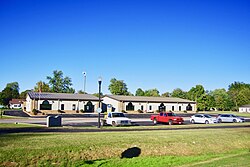
White Plains, Kentucky
Appearance
White Plains, Kentucky | |
|---|---|
 City Hall | |
| Coordinates: 37°11′4″N 87°23′5″W / 37.18444°N 87.38472°W | |
| Country | United States |
| State | Kentucky |
| County | Hopkins |
| Area | |
| • Total | 3.33 sq mi (8.62 km2) |
| • Land | 3.25 sq mi (8.42 km2) |
| • Water | 0.08 sq mi (0.20 km2) |
| Elevation | 417 ft (127 m) |
| Population | |
| • Total | 829 |
| • Density | 254.92/sq mi (98.41/km2) |
| Time zone | UTC-6 (Central (CST)) |
| • Summer (DST) | UTC-5 (CDT) |
| ZIP code | 42464 |
| Area code(s) | 270 & 364 |
| FIPS code | 21-82722 |
| GNIS feature ID | 0506635 |
White Plains is a city of Kentucky in the United States. The population was 829 at the 2020 census.[2]
Geography
[change | change source]White Plains is located in southeastern Hopkins County at 37°11′4″N 87°23′5″W / 37.18444°N 87.38472°W (37.184489, -87.384739).[3] U.S. Route 62 passes through the northern part of the community, leading east 13 miles (21 km) to Greenville and west 4 miles (6 km) to Nortonville.
According to the United States Census Bureau, White Plains has a total area of 3.33 square miles (8.62 km2), of which 3.25 square miles (8.42 km2) are land and 0.08 square miles (0.20 km2), or 2.3%, are water.[1]
References
[change | change source]- ↑ 1.0 1.1 "2020 U.S. Gazetteer Files". United States Census Bureau. Retrieved March 18, 2022.
- ↑ 2.0 2.1 "White Plains city, Kentucky". United States Census Bureau. Retrieved November 15, 2023.
- ↑ "US Gazetteer files: 2010, 2000, and 1990". United States Census Bureau. 2011-02-12. Retrieved 2011-04-23.


