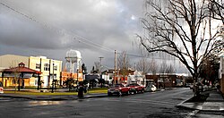
Woodburn, Oregon
Woodburn, Oregon | |
|---|---|
 | |
 Location in Oregon | |
| Coordinates: 45°08′52″N 122°52′00″W / 45.14778°N 122.86667°W | |
| Country | United States |
| State | Oregon |
| County | Marion |
| Incorporated | 1889 |
| Area | |
| • City | 5.86 sq mi (15.17 km2) |
| • Land | 5.86 sq mi (15.17 km2) |
| • Water | 0.00 sq mi (0.00 km2) |
| Elevation | 184 ft (56 m) |
| Population | |
| • City | 26,013 |
| • Density | 4,439.84/sq mi (1,714.36/km2) |
| • Metro | 400,408 |
| Time zone | UTC−8 (Pacific) |
| • Summer (DST) | UTC−7 (Pacific) |
| ZIP Code | 97071 |
| Area code(s) | 503/971 |
| FIPS code | 41-83750[4] |
| GNIS feature ID | 2412296[2] |
| Website | www.woodburn-or.gov |
Woodburn is a city in Marion County, Oregon, United States.
Woodburn is part of the Salem Metropolitan Statistical Area. It had a population of 26,013 at the 2020 census.[3]
References[change | change source]
- ↑ "ArcGIS REST Services Directory". United States Census Bureau. Retrieved October 12, 2022.
- ↑ 2.0 2.1 U.S. Geological Survey Geographic Names Information System: Woodburn, Oregon
- ↑ 3.0 3.1 "QuickFacts: Woodburn city, Oregon". United States Census Bureau. Retrieved February 22, 2024.
- ↑ "U.S. Census website". United States Census Bureau. Retrieved 2008-01-31.

