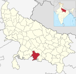
Banda district
This article needs more sources for reliability. |
Banda district | |
|---|---|
 Location of Banda district in Uttar Pradesh | |
| Country | |
| State | Uttar Pradesh |
| Division | Chitrakoot |
| Headquarters | Banda |
| Government | |
| • Lok Sabha constituencies | Banda |
| Area | |
| • Total | 4,413 km2 (1,704 sq mi) |
| Population (2011) | |
| • Total | 1,799,410 |
| • Density | 410/km2 (1,100/sq mi) |
| Demographics | |
| • Literacy | 68.11 per cent |
| • Sex ratio | 863 |
| Time zone | UTC+05:30 (IST) |
| Website | http://www.banda.nic.in/ |
Banda district is a district of Uttar Pradesh state, India.[1] Banda is side of kanpur and before chitrakoot
References[change | change source]
- ↑ Geography Names, (GeoNames ID)
