Blackpool
Blackpool | |
|---|---|
Town, Borough & Unitary authority | |
 View of Blackpool Tower & the beach | |
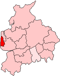
 Shown within ceremonial Lancashire | |
| Coordinates: 53°48′51″N 03°03′01″W / 53.81417°N 3.05028°W | |
| Sovereign state | United Kingdom |
| Constituent country | England |
| Region | North West England |
| Ceremonial county | Lancashire |
| Admin. HQ | Blackpool |
| Government | |
| • Type | Blackpool Borough Council |
| • Leadership: | Leader & Cabinet |
| • Executive: | |
| • MPs: | Paul Maynard (C) Gordon Marsden (L) |
| Area | |
| • Total | 13.46 sq mi (34.85 km2) |
| • Rank | 302nd |
| Population (2005 est.) | |
| • Total | 139,200 |
| • Rank | Ranked 152nd |
| • Density | 10,000/sq mi (4,000/km2) |
| Time zone | UTC+0 (Greenwich Mean Time) |
| • Summer (DST) | UTC+1 (British Summer Time) |
| Postcode | |
| ONS code | 00EY (ONS) E06000009 (GSS) |
| Ethnicity | 95.5% White 2.0% South Asian 0.9% Mixed 0.8% Black 0.6% Chinese 0.2% Other Asian Estimate[1] |
| Website | visitblackpool.com blackpool.gov.uk |
Blackpool is a seaside town in Lancashire, in the north west of England. The town is on the coast of the Irish Sea. Blackpool had a population of 142,283 as of the 2001 census.[2]
Blackpool became important for tourism during the 19th century. It is known for its beaches and amusement parks. It is also the home to a famous international ballroom dancing competition.
References[change | change source]
- ↑ ONS, Blackpool Resident Population Estimates by Ethnic Group (Percentages) Archived 2014-08-14 at the Wayback Machine , 2009. Retrieved 2012-02-06
- ↑ "About the population in Blackpool". blackpool.gov.uk. Archived from the original on 2 September 2010. Retrieved 30 June 2010.
Wikimedia Commons has media related to Blackpool.

