
Buëch
| Buëch | |
|---|---|
 Buëch River | |
 | |
| Location | |
| Country | France |
| Physical characteristics | |
| Source | |
| - location | Dauphiné Alps |
| Mouth | |
| - location | Durance |
| - coordinates | 44°12′5″N 5°56′35″E / 44.20139°N 5.94306°E |
| Length | 85 km (53 mi) |
| Basin size | 1,478 km2 (571 sq mi) |
The Buëch (Occitan: Buech) is a river in southeastern France, a right tributary of the Durance. It is also called the Grand Buëch in its upper course just to the confluence with the Petit Buëch river.
Geography[change | change source]
The Buëch river has a length of 85.2 km (53 mi) and a drainage basin with an area of approximately 1,478 km2 (571 sq mi).[1]
Its average yearly discharge (volume of water which passes through a section of the river per unit of time) is 20.10 m3/s (710 cu ft/s) at Laragne-Montéglin in the Hautes-Alpes department, for a period of 15 years.[2]

Average monthly discharge (m3/s) at Laragne-Montéglin
Course[change | change source]
The Buëch starts several kilometres to the east of col de la Croix-Haute, a mountain pass in the western side of the Massif du Dévoluy mountains, in the commune of Lus-la-Croix-Haute, Drôme department, at an elevation of about 2,325 m (7,628 ft).[3] It then flows to the southwest and gets into the Hautes-Alpes department and then flows to the south.
Finally, the river flows into the Durance river, as a right tributary, near Sisteron, in the Alpes-de-Haute-Provence department.[4]
The Buëch flows through 3 departments and 23 communes, in 2 regions:[1]
- Auvergne-Rhône-Alpes región
- Provence-Alpes-Côte d'Azur region
Main tributaries[change | change source]
The main tributaries of the Buëch river are:[1]
|
Left tributaries:
|
|
Right tributaries:
|
Gallery[change | change source]
-
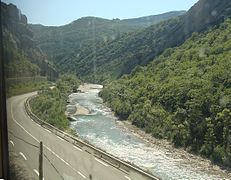
 The Buëch near Aspremont
 -
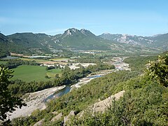
 The Buëch near Serres
 -
-
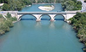 Confluence of the Durance (at left) with the Buëch in Sisteron


Related pages[change | change source]
References[change | change source]
- ↑ 1.0 1.1 1.2 "Le Buëch (X10-0400)" (in French). SANDRE - Portail national d'accès aux référentiels sur l'eau. Archived from the original on 3 March 2016. Retrieved 28 September 2016.
- ↑ "Le Buech à Laragne-Montéglin" (in French). Banque Hydro. Archived from the original on 3 March 2016. Retrieved 16 July 2017.
- ↑ "Source du Buëch" (in French). Géoportail. Retrieved 28 September 2016.
- ↑ "Confluence de la Vienne" (in French). Géoportail. Retrieved 31 July 2016.[permanent dead link]