
Centre-Val de Loire
Centre-Val de Loire
Centre e Vau de Léger (Occitan) | |
|---|---|
 | |
 Flag  Coat of arms | |
 | |
| Country | |
| Prefecture | Orléans |
| Departments | |
| Government | |
| • President of the Regional Council | François Bonneau (PS) |
| Area | |
| • Total | 39,151 km2 (15,116 sq mi) |
| • Rank | 7th |
| Population (Jan. 2019)[1] | |
| • Total | 2,573,180 |
| • Density | 66/km2 (170/sq mi) |
| Time zone | UTC+01:00 (CET) |
| • Summer (DST) | UTC+02:00 (CEST) |
| ISO 3166 code | FR-CVL |
| GDP (2012)[2] | Ranked 9th |
| Total | €67.1 billion (US$86.3 bn) |
| Per capita | €26,126 (US$33,603) |
| NUTS Region | FR2 |
| Largest city | Tours |
| Website | www |
Centre-Val de Loire is one of the administrative regions of France. Its capital is Orléans but its largest city is Tours.
It was formed in 2014 from the territories of three historical provinces: Touraine (Indre-et-Loire), Orléanais (Loiret, Eure-et-Loir, Loir-et-Cher), and Berry (Cher, Indre).
Geography[change | change source]

The Centre-Val de Loire region is the seventh largest region of France with an area of 39,150.9 km2 (15,116 sq mi).[3] It is in north central France and borders with 6 regions: Normandy to the northwest, Île-de-France to the north, Bourgogne-Franche-Comté to the east, Auvergne-Rhône-Alpes to the southeast, Nouvelle-Aquitaine to the south and Pays de la Loire to the west.
The distances from Orléans, the capital of the region, to other cities are:
- Paris, the national capital, 132 km (82 mi);
- Bordeaux, 462 km (287 mi);
- Lyon, 466 km (290 mi);
- Marseille, 759 km (472 mi);
- Montpellier, 626 km (389 mi);
- Nice, 915 km (569 mi);
- Strasbourg, 584 km (363 mi);
- Toulouse, 555 km (345 mi).
Rivers[change | change source]
The Centre-Val de Loire is crossed by the longest French river: the Loire, 1,013 km (629 mi). Some other rivers that flow through the region are:
- Eure - 229 km (142 mi).
- Loir - 317 km (197 mi).
- Cher - 368 km (229 mi).
- Loing - 142 km (88 mi).
- Indre - 279 km (173 mi).
Mountains[change | change source]
The territory of the Centre-Val de Loire region is formed mostly by large plains and low plateaus.
The Le Magnoux (46°25′43″N 2°11′54″E / 46.42861°N 2.19833°E), at 501 m (1,644 ft), is the highest point of the Centre-Val region.[4] It is in northwestern Massif Central, in the southern end of the Cher department.
The highest point of the different departments in the Centre-Val de Loire region are:[5]
| Department | Mountain | Elevation |
|---|---|---|
| Cher | Le Magnoux | 501 m (1,644 ft) |
| Eure-et-Loir | Butte de Rougemont | 287 m (942 ft) |
| Indre | Terrior Randoin | 457 m (1,499 ft) |
| Indre-et-Loire | Signal de la Ronde | 186 m (610 ft) |
| Loir-et-Cher | Bois des Vallèes | 256 m (840 ft) |
| Loiret | Col des Étourneaux | 273 m (896 ft) |
Departments[change | change source]
The Centre-Val de Loire region is formed by 6 departments:
| ISO 3166-2 |
Shield | Department | Prefecture | Arr. | Cant. | Comm. | Population (2014)[6] |
Area (km²) |
Density (Inh./km²) |
|---|---|---|---|---|---|---|---|---|---|
| FR-18 | Cher | Bourges | 3 | 19 | 290 | 310,270 | 7,235.0 | 42.9 | |
| FR-28 | Eure-et-Loir | Chartres | 4 | 15 | 375 | 433,762 | 5,880.0 | 73.8 | |
| FR-36 | Indre | Châteauroux | 4 | 13 | 243 | 226,175 | 6,790.6 | 33.3 | |
| FR-37 | Indre-et-Loire | Tours | 3 | 19 | 273 | 603,924 | 6126.7 | 98.6 | |
| FR-41 | Loir-et-Cher | Blois | 3 | 15 | 276 | 333,567 | 6,343.4 | 52.6 | |
| FR-45 | Loiret | Orléans | 3 | 21 | 326 | 669,737 | 6,775.2 | 98.9 | |
| Total of the Region | 20 | 102 | 1,783 | 2,577,435 | 39,150.9 | 65.8 | |||
Arr. = Arrondissements Cant. = Cantons Comm. = Communes
Demographics[change | change source]
As of 1 January 2014[update], the Centre-Val de Loire region had a population of 2,577,435,[7] for a population density of 65.8 inhabitants/km2.

The main cities with more than 20,000 inhabitants (2014) in the region are:
| INSEE code |
City | Department | Population (2014) |
|---|---|---|---|
| 37261 | Tours | Indre-et-Loire | 136,125 |
| 45234 | Orléans | Loiret | 114,977 |
| 18033 | Bourges | Cher | 66,528 |
| 41018 | Blois | Loir-et-Cher | 46,351 |
| 36044 | Châteauroux | Indre | 44,479 |
| 28085 | Chartres | Eure-et-Loir | 38,728 |
| 37122 | Joué-lès-Tours | Indre-et-Loire | 37,748 |
| 28134 | Dreux | Eure-et-Loir | 31,191 |
| 18279 | Vierzon | Cher | 27,050 |
| 45232 | Olivet | Loiret | 21,192 |
| 45147 | Fleury-les-Aubrais | Loiret | 20,791 |
Gallery[change | change source]
-
 Castle of Tours.
 -
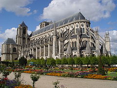 Saint-Etienne cathedral, Bourges.
 -
 Blois City hall.
 -
 Musée Hôtel Bertrand, Châteauroux.

_16-09-2006.jpg)


Related pages[change | change source]
References[change | change source]
- ↑ "Téléchargement du fichier d'ensemble des populations légales en 2019". The National Institute of Statistics and Economic Studies. 28 December 2020.
- ↑ INSEE. "Produits intérieurs bruts régionaux et valeurs ajoutées régionales de 1990 à 2012". Retrieved 2014-03-04.
- ↑ "Région du Centre-Val de Loire (24)". Comparateur de territoire (in French). Institut national de la statistique et des études économiques - INSEE. Retrieved 16 August 2017.
- ↑ "Le Magnoux, France". Peakbagger.com. Retrieved 29 July 2017.
- ↑ "France Department High Points". Peakbagger.com. Retrieved 16 August 2017.
- ↑ "Populations légales 2014 des départements et des collectivités d'outre-mer" (in French). Institut national de la statistique et des études économiques - INSEE. Retrieved 16 August 2017.
- ↑ "Populations légales 2014: Recensement de la population - Population des régions" (in French). Institut national de la statistique et des études économiques - INSEE. Retrieved 16 August 2017.
Other websites[change | change source]
- Regional Council website Archived 2016-01-09 at the Portuguese Web Archive (in French)
- Prefecture of the region (in French)
| International | |
|---|---|
| National | |
| Geographic | |
| Other | |