
Dukes County, Massachusetts
Dukes County | |
|---|---|
 Town Hall, Edgartown | |
 Seal | |
 Location within the U.S. state of Massachusetts | |
 Massachusetts's location within the U.S. | |
| Coordinates: 41°24′53″N 70°36′46″W / 41.414841°N 70.612679°W | |
| Country | |
| State | |
| Founded | 1695 |
| Named for | James, Duke of York |
| Seat | Edgartown |
| Largest town | Oak Bluffs |
| Area | |
| • Total | 491 sq mi (1,270 km2) |
| • Land | 103 sq mi (270 km2) |
| • Water | 388 sq mi (1,000 km2) 79% |
| Population (2020) | |
| • Total | 20,600 |
| • Density | 199.6/sq mi (77.1/km2) |
| Time zone | UTC−5 (Eastern) |
| • Summer (DST) | UTC−4 (EDT) |
| Congressional district | 9th |
| Website | www |
Dukes County is a county in the U.S. state of Massachusetts. As of the 2020 census, the population was 20,600.[1] The county seat is Edgartown.[2]
References[change | change source]
- ↑ "QuickFacts: Dukes County, Massachusetts". United States Census Bureau. Retrieved January 3, 2024.
- ↑ "Find a County". National Association of Counties. Archived from the original on July 4, 2012. Retrieved June 7, 2011.
Municipalities and communities of Dukes County, Massachusetts, United States | ||
|---|---|---|
| Towns | 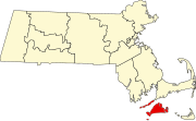 | |
| CDPs | ||
| Other villages | ||
| Indian reservation | ||
Boston (capital) | ||
| Topics | ||
| Regions | ||
| Counties | ||
| Cities |
| |
