Fullerton, North Dakota
Fullerton, North Dakota | |
|---|---|
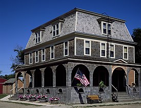
 Carroll House, a historic hotel in Fullerton | |
 Location of Fullerton, North Dakota | |
| Coordinates: 46°09′48″N 98°25′38″W / 46.16333°N 98.42722°W | |
| Country | United States |
| State | North Dakota |
| County | Dickey |
| Founded | 1887 |
| Area | |
| • Total | 0.39 sq mi (1.01 km2) |
| • Land | 0.39 sq mi (1.01 km2) |
| • Water | 0.00 sq mi (0.00 km2) |
| Elevation | 1,444 ft (440 m) |
| Population | |
| • Total | 62 |
| • Density | 158.97/sq mi (61.38/km2) |
| Time zone | UTC–6 (Central (CST)) |
| • Summer (DST) | UTC–5 (CDT) |
| ZIP Code | 58441 |
| Area code | 701 |
| FIPS code | 38-28780 |
| GNIS feature ID | 1036047[2] |
Fullerton is a city in Dickey County, North Dakota, United States. The population was 62 at the 2020 census.[3]
The city is said to be named after Dr. Samuel Fuller.[4]
The Ranch House is a local restaurant in the area.
History[change | change source]
"…In 1882 Dickey County was a wild, unbroken prairie, with not a foot of land occupied or a sod turned. Now, i don't believe there is a foot of land in the county that is not owned, and most of it by actual settlers."
Fullerton was founded in 1888.
The Carroll House is a registered national historical site in Fullerton.
References[change | change source]
- ↑ "2020 U.S. Gazetteer Files". United States Census Bureau. Retrieved July 24, 2022.
- ↑ 2.0 2.1 U.S. Geological Survey Geographic Names Information System: Fullerton, North Dakota
- ↑ 3.0 3.1 "Profile of General Population and Housing Characteristics: 2020 Demographic Profile Data (DP-1): Fullerton city, North Dakota". United States Census Bureau. Retrieved February 17, 2024.
- ↑ "History of Fullerton, ND". fullertonnd.com. Retrieved 2020-02-11.

