Talkeetna, Alaska
Talkeetna, Alaska
K'dalkitnu | |
|---|---|
 | |
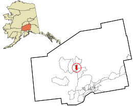
 Location in Matanuska-Susitna Borough and the state of Alaska. | |
| Coordinates: 62°18′41″N 150°5′13″W / 62.31139°N 150.08694°W | |
| Country | United States |
| State | Alaska |
| Borough | Matanuska-Susitna |
| Government | |
| • Borough mayor | Edna DeVries |
| • State senator | Mike Shower (R) |
| • State rep. | Kevin McCabe (R) |
| Area | |
| • Total | 96.35 sq mi (249.54 km2) |
| • Land | 94.22 sq mi (244.02 km2) |
| • Water | 2.13 sq mi (5.52 km2) |
| Elevation | 348 ft (106 m) |
| Population (2020) | |
| • Total | 1,055 |
| • Density | 11.20/sq mi (4.32/km2) |
| Time zone | UTC−9 (Alaska (AKST)) |
| • Summer (DST) | UTC−8 (AKDT) |
| ZIP code | 99676 |
| Area code | 907 |
| FIPS code | 02-74830 |
| GNIS feature ID | 1410591 |
Talkeetna (Dena'ina: K'dalkitnu) is a census-designated place (CDP) in Matanuska-Susitna Borough, Alaska, United States. It began as a district headquarters of the Alaska Railroad in 1916.[2]
References[change | change source]
- ↑ "2020 U.S. Gazetteer Files". United States Census Bureau. Archived from the original on March 18, 2021. Retrieved October 29, 2021.
- ↑ "Talkeetna history". Talkeetna Chamber of Commerce. Archived from the original on May 12, 2008. Retrieved June 15, 2009.

