Viroflay
Viroflay | |
|---|---|
 | |
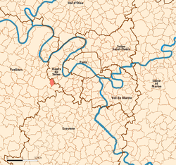
 Location (in red) within Paris inner and outer suburbs | |
| Coordinates: 48°48′00″N 2°10′01″E / 48.8°N 2.167°E | |
| Country | France |
| Region | Île-de-France |
| Department | Yvelines |
| Arrondissement | Versailles |
| Intercommunality | Grand Parc |
| Area 1 | 3.49 km2 (1.35 sq mi) |
| Population (2006) | 16,331 |
| • Density | 4,700/km2 (12,000/sq mi) |
| Time zone | UTC+01:00 (CET) |
| • Summer (DST) | UTC+02:00 (CEST) |
| INSEE/Postal code | 78686 / |
| Elevation | 92–176 m (302–577 ft) |
| 1 French Land Register data, which excludes lakes, ponds, glaciers > 1 km2 (0.386 sq mi or 247 acres) and river estuaries. | |
Viroflay is a French commune of Yvelines, in France.
It is near Versailles and Vélizy-Villacoublay.
Its current mayor is Olivier Lebrun.
The people who live there are called Viroflaysiens.


