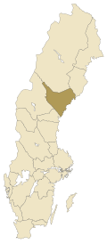
Ångermanland
Ångermanland | |
|---|---|
 | |
| Coordinates: 63°09′14″N 17°14′17″E / 63.154°N 17.238°E | |
| Country | Sweden |
| Land | Norrland |
| Counties | Västernorrland County Jämtland County Västerbotten County |
| Area | |
| • Total | 19,507 km2 (7,532 sq mi) |
| Population (2009)[1] | |
| • Total | 132,689 |
| • Density | 6.8/km2 (18/sq mi) |
| Ethnicity | |
| • Language | Swedish (North Swedish) |
| Culture | |
| • Flower | Heartsease |
| • Animal | Beaver |
| • Bird | — |
| • Fish | Lavaret |
| Time zone | UTC+1 (CET) |
| • Summer (DST) | UTC+2 (CEST) |
Ångermanland is a historical province in northern Sweden. A major river is the Ångerman River.
References[change | change source]
Other websites[change | change source]
![]() Media related to Ångermanland at Wikimedia Commons
Media related to Ångermanland at Wikimedia Commons

