Arapaho, Oklahoma
Appearance
Arapaho, Oklahoma | |
|---|---|
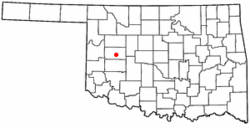
 Location of Arapaho, Oklahoma | |
| Coordinates: 35°34′40″N 98°57′34″W / 35.57778°N 98.95944°W | |
| Country | United States |
| State | Oklahoma |
| County | Custer |
| Area | |
| • Total | 0.70 sq mi (1.81 km2) |
| • Land | 0.70 sq mi (1.81 km2) |
| • Water | 0.00 sq mi (0.00 km2) |
| Elevation | 1,660 ft (510 m) |
| Population (2020) | |
| • Total | 668 |
| • Density | 955.65/sq mi (369.03/km2) |
| Time zone | UTC-6 (Central (CST)) |
| • Summer (DST) | UTC-5 (CDT) |
| ZIP code | 73620 |
| Area code | 580 |
| FIPS code | 40-02500[3] |
| GNIS feature ID | 2412374[2] |
Arapaho is a town in the U.S. state of Oklahoma. It is the county seat of Custer County.
References
[change | change source]- ↑ "ArcGIS REST Services Directory". United States Census Bureau. Retrieved September 20, 2022.
- ↑ 2.0 2.1 U.S. Geological Survey Geographic Names Information System: Arapaho, Oklahoma
- ↑ "U.S. Census website". United States Census Bureau. Retrieved January 31, 2008.
