Custer County, Oklahoma
Custer County | |
|---|---|
 Weatherford Armory | |
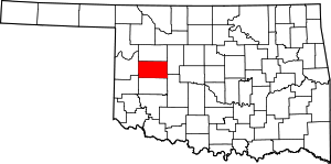
 Location within the U.S. state of Oklahoma | |
 Oklahoma's location within the U.S. | |
| Coordinates: 35°38′N 99°01′W / 35.64°N 99.01°W | |
| Country | |
| State | |
| Founded | 1891 |
| Named for | General George A. Custer |
| Seat | Arapaho |
| Largest city | Weatherford |
| Area | |
| • Total | 1,002 sq mi (2,600 km2) |
| • Land | 989 sq mi (2,560 km2) |
| • Water | 13 sq mi (30 km2) 1.3% |
| Population (2020) | |
| • Total | 28,513 |
| • Density | 28/sq mi (11/km2) |
| Time zone | UTC−6 (Central) |
| • Summer (DST) | UTC−5 (CDT) |
| Congressional district | 3rd |
| Website | custer |
Custer County is a county in the U.S. state of Oklahoma. It was named in honor of General George Armstrong Custer. As of 2020, 28,513 people lived there.[1] Its county seat is Arapaho.
Geography[change | change source]
The county has a total area of 1,002 square miles.
References[change | change source]
- ↑ "QuickFacts: Custer County, Oklahoma". United States Census Bureau. Retrieved January 19, 2024.
Wikimedia Commons has media related to Custer County, Oklahoma.

